
Study guide · SKS
Coastal Skipper Certificate
The SKS catalogue contains 638 questions. This study guide follows the five official examination subjects and explains the principles behind the model answers.
Chapter 1 · 36 questions
Charts and nautical publications
A position is only as reliable as the chart on which it is plotted. This chapter combines corrections, chart datums, publications and passage preparation into one workflow.
Before departure: complete, suitable and corrected
Before departure, nautical charts and publications must be complete and fully corrected. When approaching a coast, use the largest-scale chart available, because it shows the navigational marks, depths and hazards required for pilotage.
German official charts bear the correction stamp of the BSH or an authorised chart-correction service. On British charts, the correction status is recorded on the reverse; "Corrected up to N.T.M. 3595 1998" means that Admiralty Notices to Mariners up to notice 3595 of 1998 have been applied. Leisure-craft chart folios are not automatically corrected after printing and must be updated from Notices to Mariners before use.
For a night passage, courses and alteration points are planned in advance, shoals and hazards are marked clearly, the expected dipping distance of important lights is calculated and the route is checked for unlit buoys. Plot the vessel's position regularly so that any departure from the planned track is detected before the next buoy is reached.
WGS 84 and the chart datum
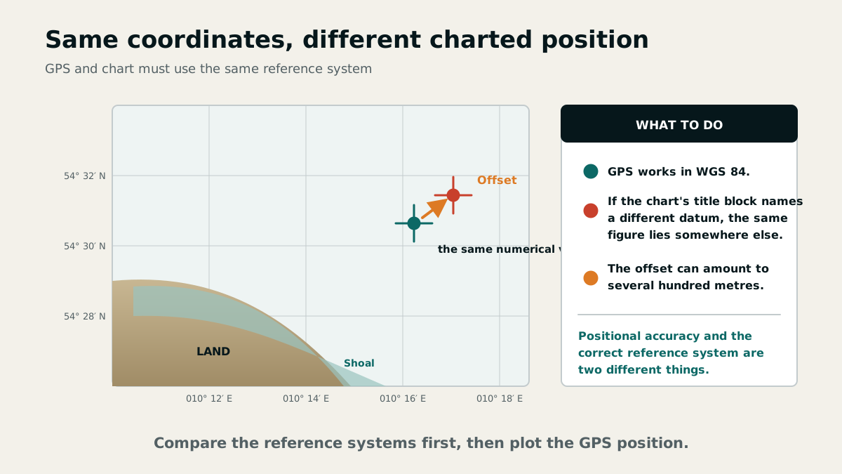
GPS positions are normally referenced to the worldwide WGS 84 datum. An older chart may use a different datum, so identical latitude and longitude figures need not identify the same point. Typical offsets are about 20 to 200 metres, although larger differences are possible.
The datum and any stated offset are printed in the chart margin beneath the title. Either select the chart datum in the receiver, apply the stated north/south and east/west corrections to the GPS position, or use a WGS 84 chart. Receiver accuracy does not remove a datum error.
WGS 84 means World Geodetic System 1984. It is a global reference ellipsoid approximating the shape of the Earth and can therefore be used worldwide, but its compatibility with the chart in use must still be checked.
The correction note explicitly gives the displacement of WGS 84 positions in minutes northwards or southwards and westwards or eastwards to agree with the chart. Take the values and directions from that specific chart.
Notices to Mariners, local Notices to Mariners and navigational warnings
The BSH publishes Notices to Mariners (NfS) weekly, both online and in booklet form, in German and English. They report safety-related changes on German maritime waterways, on the high seas and in European and adjacent territorial waters. British Admiralty Notices to Mariners must be used for British charts outside that coverage.
Local Notices to Mariners (BfS) are issued by the responsible federal or state waterway authority. They cover German maritime waterways and the exclusive economic zone, including changes to lights and buoyage, new wrecks, altered depths, works, dredging and closures. They are published at official notice boards and through ELWIS.
Navigational warnings (NWN) are issued by vessel traffic service centres for their areas and by the Emden maritime warning service for the entire German warning area. The qualifier vital identifies a life-threatening danger. From 1 April to 31 October, vital warnings for recreational craft are also forwarded to selected broadcasters.
P and T notices are not entered permanently on the chart: P announces a preliminary measure and T a temporary condition. Before every passage, determine which notices remain in force and mark them provisionally on the chart.
Which publication answers what question?
Lists of Lights describe lighthouses, light vessels and major light buoys together with their positions; buoys less than eight metres high are omitted. Symbols and abbreviations are explained in Chart 1/INT 1. The characteristics of floating marks are also listed in Annex I to the German Maritime Waterways Regulations.
Sailing directions cover shipping information, natural conditions, coastal descriptions and pilotage directions. Bridge signals are shown in sailing directions, port guides and charts. Directions in nautical publications are true bearings, stated in degrees clockwise from north.
Restricted and prohibited areas are identified from charts, local notices and navigational warnings. Minimum navigational equipment for a coastal yacht includes a steering compass, hand-bearing compass, electronic navigation receiver, log, echo sounder or lead line, binoculars, barometer, timepiece, corrected charts, nautical publications and a logbook. The equipment provides independent means of cross-checking rather than interchangeable substitutes.
One detail the List of Lights is regularly asked about: what its elevations are measured from depends on the area. In waters with tides — the North Sea, for instance — they are given above mean high water; in tideless waters such as the Baltic, above mean water level. Anyone feeding the height of a light into the range formula is therefore working from a different reference plane depending on the area.
Chapter 2 · 16 questions
Lights and navigation marks
Lights are not merely identified; they are used geometrically. The key is to distinguish character, luminous range and geographic range and to read special marks correctly.
Leading lights, sector lights and gate lights
A leading-light pair consists of a front and a rear light. When they appear vertically in line, the vessel is on the marked leading line, for example through a fairway or between shoals. A sector light, by contrast, is a single light with differently coloured or characterised safe and warning sectors.
Sector limits are bearings towards the light. A red warning sector stated as 030° to 042° therefore lies in the reciprocal south-west quadrant when viewed from the light. A gate-light pair consists of two lights of equal height, intensity and character positioned opposite each other across the fairway axis.
Luminous range, nominal range and geographical range
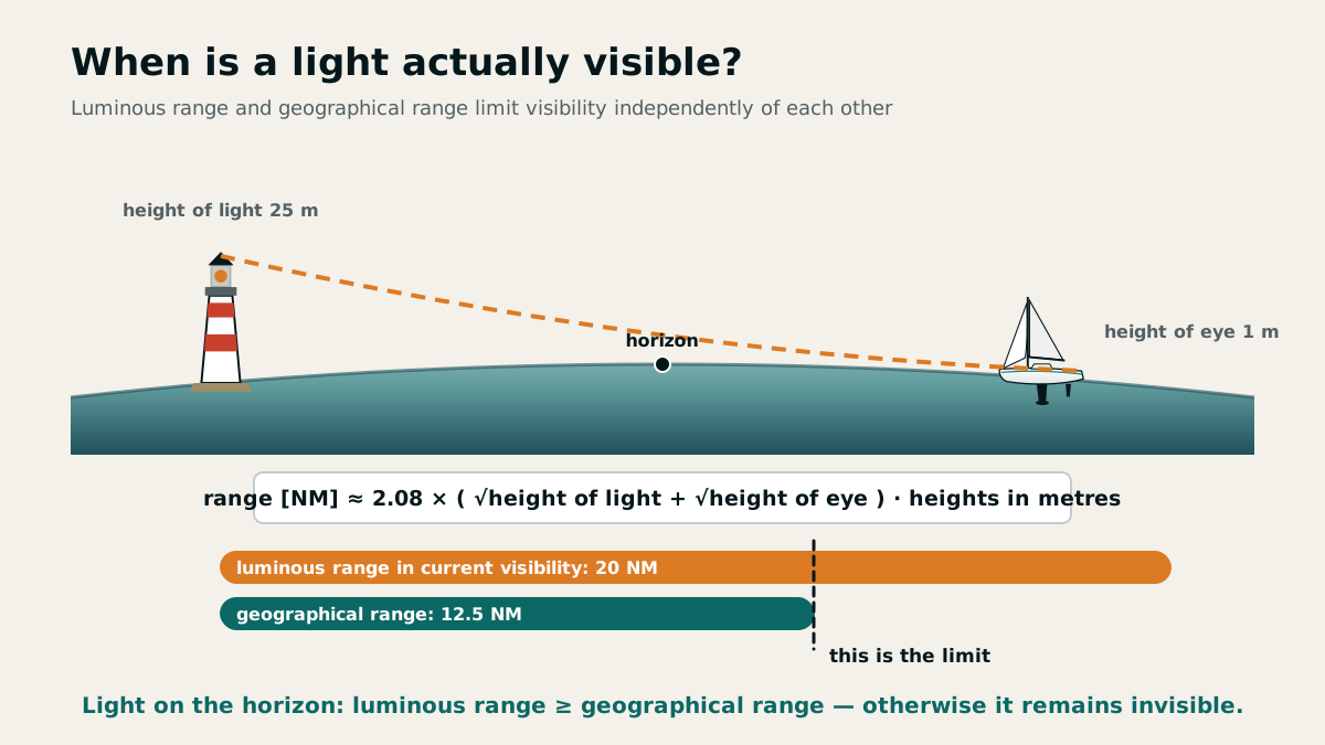
The luminous range is the distance at which a light is just clearly visible. It depends on the light's intensity and atmospheric transmissivity. The nominal range is a standardised comparison value based on a daytime meteorological visibility of 10 nautical miles; a charted entry of "18 M" therefore means a nominal range of 18 nautical miles.
The geographical range is geometric: it is the distance at which the light can be seen over the curvature of the Earth and depends on the elevation of the light and the observer's height of eye. For a distance obtained when a light dips or rises, the actual luminous range must be at least as great as the geographical range. Distance tables are provided in German and British Lists of Lights.
In tidal waters such as the North Sea, elevations refer to mean high water; in non-tidal waters such as the Baltic Sea, they refer to mean water level. The geometrical calculation therefore uses the reference appropriate to the area.
Special marks and closed water areas
Besides lateral marks, recreational craft must pay particular attention to cardinal marks placed around general dangers and to yellow special marks. Anchorages, warning areas and other special features may be marked by yellow can or spar buoys or by posts; any associated lights are yellow.
Restricted-area marks also carry a broad red band and a black restricted-area inscription on can or light buoys. White buoys or posts bearing a yellow cross or yellow band mark water areas closed for bathing: power-driven vessels and personal watercraft must not enter.
Chapter 3 · 16 questions
Courses and the magnetic compass
Two separate errors lie between true north and the magnetic compass indication. Treating them in the correct order makes the conversion systematic.
Three north references and three angles
True north (TN) points along the meridian towards the geographic North Pole. Magnetic north (MN) follows the Earth's magnetic field and varies with position and year. Compass north (CN) is the direction actually indicated after the vessel's own magnetic influence has acted on the compass.
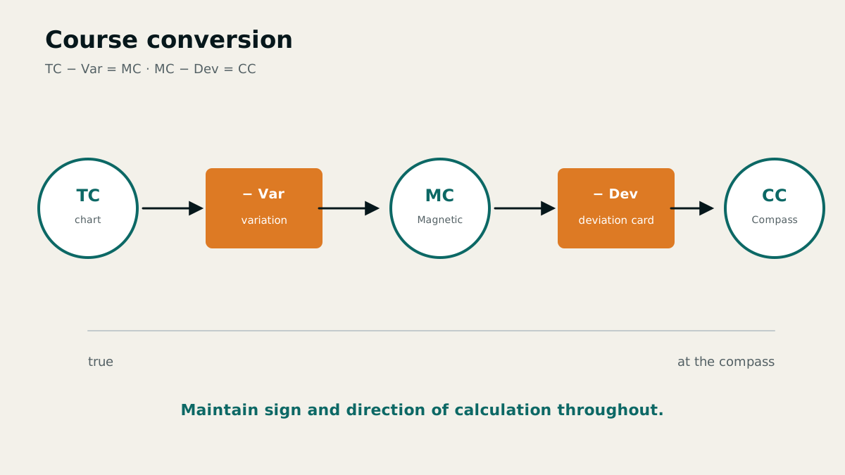
The angle between true and magnetic north is variation. The angle between magnetic and compass north is deviation. Together they form compass error. Variation, corrected to the current year, comes from the chart; deviation for the course being steered comes from the vessel's deviation card.
To correct a magnetic-compass bearing, first apply the deviation corresponding to the compass course being steered, then apply the current variation. Do not guess the signs; follow the chosen conversion convention consistently.
Why each compass needs its own table
Deviation depends on both the vessel and the course steered. Fixed installations or a lasting change in the vessel's magnetic condition alter it over time. Nearby electronic equipment, tools, a hand-bearing compass or direct-current cables may cause temporary changes.
Regular compass checks are therefore essential: they verify the compass and the values on the deviation card. Magnetisable material should be kept at least one metre away. A spherical compass remains readable at larger angles of heel and its shape magnifies the compass card.
Speed and course: through the water is not over the ground
A conventional log indicates speed through the water (STW). GPS indicates speed over the ground (SOG) and course over the ground (COG). Current and wind separate these quantities, so log speed must not be used uncritically to advance a position on the chart.
As a quick conversion, metres per second multiplied by two gives approximately knots. This rule of thumb does not replace an accurate navigational calculation, but it provides an immediate order of magnitude.
Minimum equipment even for short coastal passages includes a steering compass, hand-bearing compass, depth sounder or lead line, log and clock. Together they form an independent cross-check: if satellite navigation fails or becomes implausible, course, depth, speed and time can still be measured.
Chapter 4 · 8 questions
Position fixing and set and drift
An observed position is a geometric construction from independent position lines. Its quality depends more on geometry and cross-checking than on neat pencil lines.
Obtaining a reliable cut of position lines
Classical terrestrial position fixing uses cross bearings, bearing and distance, or bearing and sounding. If only one charted object is visible, combine its bearing with a dipping distance, radar range or sounding.
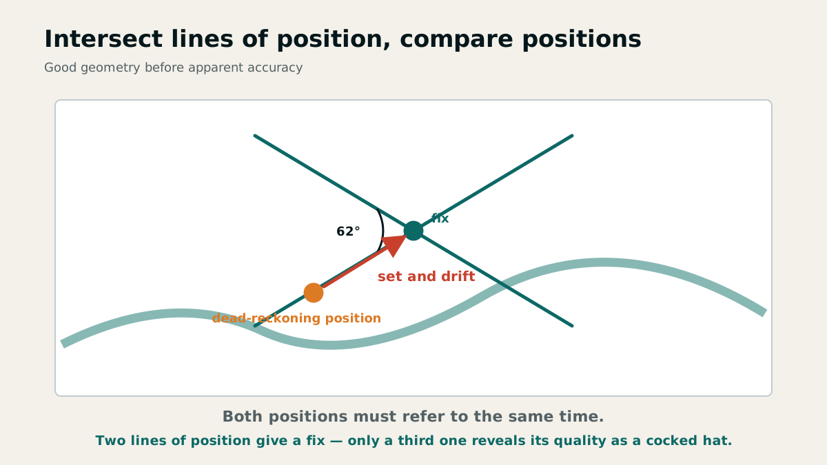
Two bearings should intersect at no less than 30° and no more than 150°. Very acute or nearly straight angles magnify small bearing errors into large positional uncertainty. A sounding provides a useful line of position only where the seabed is sufficiently regular and steep.
Dead-reckoning position, fix, and set and drift
A dead-reckoning position is calculated from course, speed and time; a fix comes from an independent observation. The set-and-drift vector gives direction and distance from the dead-reckoning position to the fix, both reduced to the same time.
Possible causes include inaccurate helming or dead reckoning, course error, and missing or incomplete allowances for current and wind. Set and drift are therefore diagnostic, showing how the assumptions made since the previous reliable position differed from reality.
Plotting positions regularly limits the time over which errors can accumulate unnoticed. After every reliable fix, restart dead reckoning from that checked position.
Regular position plotting reveals departures from the course line early and reliably. Correct the course where necessary.
Chapter 5 · 20 questions
Tides, water level and depth
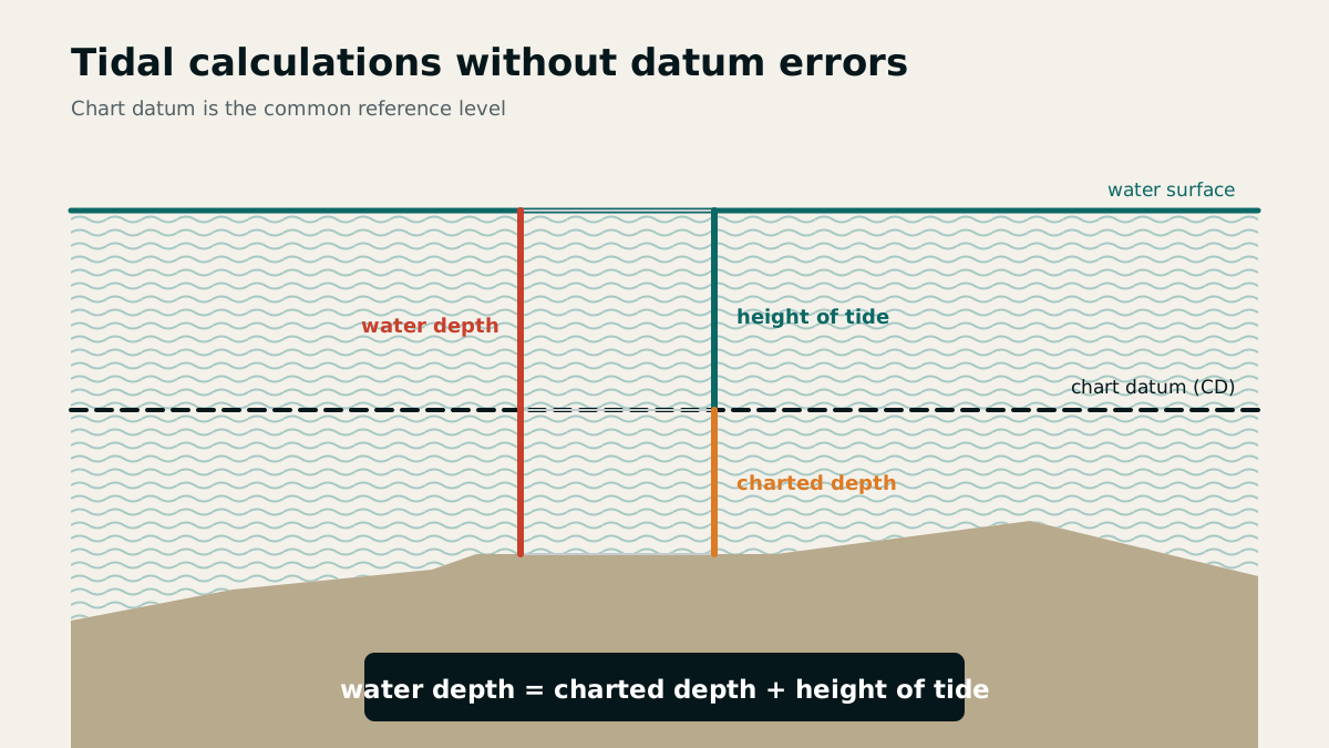
Tidal calculation is a height calculation tied to time. Charted depth, height of tide and observed depth can only be combined when their reference levels are clear.
Spring tides, neap tides and the age of the tide
At spring tide, the Sun, Earth and Moon are aligned and their effects reinforce one another. High waters are especially high, low waters especially low, and tidal streams are generally stronger. At neap tide, the Earth–Sun and Earth–Moon lines are roughly at right angles; the tidal range and streams are smaller.
The age of the tide indicates whether conditions are at neaps, mean tides or springs. A lunar day averages 24 hours 50 minutes, so high and low water occur later each day and the final event may move into the next calendar day.
Chart datum and the depth formula
Depths on German nautical charts are referred to chart datum (CD). In the Baltic Sea, chart datum corresponds to mean water level; in the North Sea and English Channel it is Lowest Astronomical Tide (LAT). The exact definition is stated on the chart.
Charted depth is measured from chart datum and the height of tide lies above it. Thus water depth = charted depth + height of tide, or charted depth = water depth − height of tide. An underlined drying height such as 2.3 identifies a feature 2.3 metres above chart datum that may uncover.
A sounding taken away from low water may exceed the depth at the next low water. Always record the time of a sounding: only then can the tide table show whether the water was rising or falling and what height of tide applied to the measurement.
Why the tide table cannot guarantee actual conditions
Tide tables describe astronomical conditions. Wind and unusually high or low atmospheric pressure can alter both water levels and times significantly: high and low water may occur higher, lower, earlier or later than predicted.
Even in non-tidal waters, the strength, duration and direction of the wind can cause substantial changes in water level and wind-driven currents. In the Baltic, piled-up water may later surge back. In tidal waters, wind effects are superimposed on the astronomical tide and tidal stream.
A water-level gauge is a scale indicating water level. Obtain tidal streams from tidal stream atlases, sailing directions and chart tables referenced to high water at a standard port. Planning and observation must agree.
The second reason tabulated values shift is the wind. It sets up currents and changes in water level of its own that are added to the tidal stream and the tide — an onshore wind piles the water up, an offshore wind pushes it out. The tables know nothing of that contribution.
Chapter 6 · 22 questions
GPS, radar and AIS
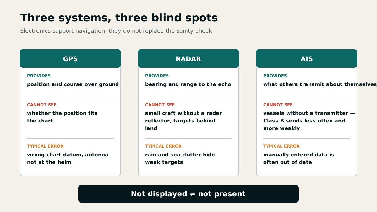
Electronic navigation provides fast and precise data, but not built-in truth. Availability, datum, sensor errors and operation must be checked independently.
GPS and DGPS: principle and accuracy
GPS means Global Positioning System. The receiver measures the travel time of signals from several satellites, derives their ranges and calculates its position. Typical realistic accuracy is about 10 to 20 metres for GPS and 1 to 10 metres for DGPS, in each case at roughly 95 per cent probability.
DGPS means Differential GPS. Reference stations at accurately surveyed positions determine regional errors and broadcast corrections by radio. A statement such as "100 m with 95 per cent probability" means that the vessel lies within an error circle of 100 metres radius in 95 per cent of observations; one observation in twenty may be less accurate.
Assess reliability from HDOP, the number and distribution of satellites received, and comparison with the dead-reckoning position and independent methods. The MOB key stores the position at the instant it is pressed and then displays bearing and distance back to it. A waypoint is simply the geographical coordinates of a point to be approached or checked.
Three advantages of GPS are worldwide operation, a continuously available position display and small position error. The subsequent checks address the limits of these advantages.
Antenna, faults and operating errors
The GPS antenna needs an unobstructed view of the sky and a sound electrical installation. Obstruction degrades satellite geometry. Erroneous indications may also occur near powerful transmitters, airports or naval installations, or while the vessel's own VHF radio or other electrical equipment is operating.
An electronic position remains an observation that must be checked for plausibility. Chart datum, antenna installation and interference are independent error sources; correcting one does not make the others harmless.
Radar: bearing line and range circle
On radar, the bearing of a charted object gives a line of position and the range measured with the VRM gives a range circle; their intersection fixes the vessel's position. A short pulse length and smaller range scale improve separation between targets that are close together.
Small craft and buoys may disappear in sea or rain clutter, be lost through incorrect settings or an excessive range scale, or be hard to identify because the vessel's heading is unstable in a head-up display. A missing echo is therefore not proof of clear water.
AIS: valuable data with clear limits
AIS is the Automatic Identification System. Equipped vessels transmit their identity and vessel data automatically and may also exchange safety-related messages. The VHF range for merchant ships is often 20 to 30 nautical miles and depends chiefly on antenna height. Relay stations can extend the range and overcome shadowing.
AIS transmits static data such as identity, call sign and dimensions; dynamic sensor data such as UTC, position, heading, COG and SOG; and voyage-related data such as draught, destination and ETA. A position can be wrong if the source GPS position is wrong, while manually entered data may be outdated or entered carelessly.
A vessel appears only if it is fitted with AIS, is transmitting, provides a valid position and is not omitted because of display or capacity limits such as target overflow. This matters especially to recreational craft, which may produce a weak radar echo or disappear in clutter. A craft not transmitting AIS must not assume that it will be visible on another vessel's combined radar/AIS display.
Chapter 7 · 25 questions
Navigation lights and day shapes
Lights are read from top to bottom and from the observer's viewpoint. Basic lights, additional lights and movement together form a reliable traffic picture.
Basic lights, direction of view and times
Lights are exhibited from sunset to sunrise and also by day in restricted visibility. A sailing vessel proceeding under sail and machinery displays the lights prescribed for a power-driven vessel of her length at night and, by day, a black cone apex down in the forepart.
For every identification, first establish the aspect: a masthead light with both sidelights indicates an almost head-on view; a masthead light with one sidelight indicates an oblique aspect; a sternlight alone indicates the stern sector. Yawing can make sidelights appear intermittently but does not automatically change the encounter situation.
A vessel of less than 12 metres is not required to exhibit the full lights or shapes for a vessel not under command, but must then indicate her condition by all available means, such as radio, sound or light signals and a powerful hand-held light.
Not under command and restricted in ability to manoeuvre
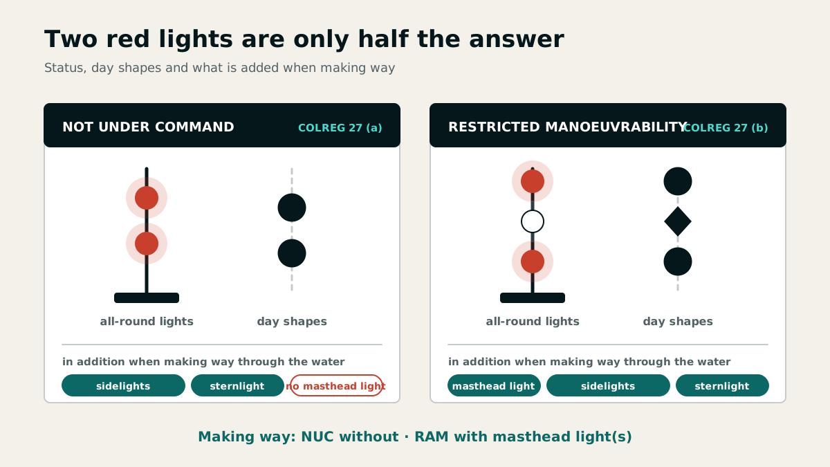
A vessel not under command exhibits two red all-round lights in a vertical line at night and two black balls by day. When making way, she also shows sidelights and a sternlight. A vessel restricted in her ability to manoeuvre exhibits red–white–red or ball–diamond–ball.
When making way, a RAM vessel also carries the navigation lights of a power-driven vessel; when not making way, she shows only red–white–red, and when at anchor also the anchor lights. During underwater operations, two green all-round lights mark the side on which vessels may pass and two red lights the obstructed side; by day the corresponding shapes are diamonds and balls.
A vessel with statutory right of way under the German Maritime Waterways Regulations exhibits red–white–red in addition to her navigation lights and is treated as restricted in her ability to manoeuvre. The signal group can therefore arise from the vessel's work or legal status, not only from a defect.
Tows and special hazards
A tow exceeding 200 metres in length displays a black diamond on both towing vessel and tow by day. At night, the towing vessel shows three masthead lights in a vertical line, sidelights, a sternlight and a yellow towing light above it; a manned tow shows sidelights and a sternlight.
A vessel engaged in fishing other than trawling, including a drift-net vessel, exhibits red over white. If her gear extends more than 150 metres horizontally, an additional white all-round light indicates the direction of the gear; when making way, sidelights and a sternlight are added. In restricted visibility she sounds one prolonged followed by two short blasts at intervals of not more than two minutes.
Under the German Maritime Waterways Regulations, a motorised recreational craft towing another recreational craft is not treated as a power-driven vessel towing under the COLREGs and therefore carries no special towing signals. This local exception must not be applied to commercial tows.
A red all-round light together with the continuous short–long sound signal is the keep-away signal for a release of dangerous or radioactive substances or a risk of explosion. Increase distance, do not operate electrical switches and avoid naked flames.
At Kiel Canal locks, an interrupted red light means entry prohibited; interrupted white over interrupted red means clearance is being prepared; interrupted white alone permits recreational craft to enter. Red–red–green displayed ashore indicates an exceptional obstruction to navigation at night.
Light configurations in encounter situations
A vessel approaching from within the sternlight sector remains an overtaking vessel and must keep out of the way, even if yawing briefly reveals a sidelight. When two power-driven vessels meet on reciprocal or nearly reciprocal courses, both alter to starboard and each sounds one short blast.
When two power-driven vessels cross, the vessel that has the other on her starboard side keeps out of the way; the other maintains course and speed. Between sailing vessels, tack and windward position decide. A vessel with the wind on the port side that cannot determine the other vessel's tack keeps out of the way.
At least five short and rapid blasts are the required doubt or warning signal when the other vessel's intentions are unclear or her action is insufficient. Regardless of that signal, action to avoid collision at the last moment becomes mandatory as soon as collision cannot otherwise be avoided.
Chapter 8 · 5 questions
Sound signals in fog and danger
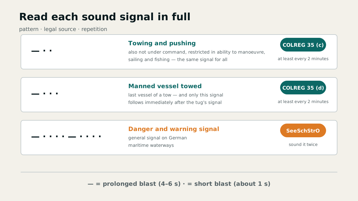
A sound signal consists of its pattern, repetition interval and vessel status. All three are needed for a complete examination answer.
A tow and a vessel aground in fog
A tow under way announces itself with two immediately consecutive signals: the towing vessel sounds one prolonged and two short blasts, followed immediately by one prolonged and three short blasts from the manned tow. The sequence is repeated at intervals of approximately one minute.
A vessel aground of less than 100 metres first sounds three distinct strokes on the bell, then rings the bell rapidly for about five seconds, and finally sounds three more distinct strokes. The additional separate strokes distinguish her from an ordinary vessel at anchor.
Action on hearing a signal ahead
If, in restricted visibility, a vessel without radar hears a fog signal apparently forward of her beam, she reduces speed to the minimum at which she can be kept on course. If necessary, she takes all way off.
She navigates with extreme caution until danger of collision is over. A course alteration based only on an assumed position of the other vessel does not replace this procedure.
General danger and warning signal
If a vessel on a German maritime waterway endangers another vessel or is herself endangered, she gives the general danger and warning signal in good time whenever possible: one prolonged and four short blasts, repeated twice.
During underwater operations, day shapes or lights supplement the sound signal: balls or red all-round lights mark the obstructed side, while diamonds or green all-round lights mark the side on which vessels may pass. Sound and visual signals form one traffic picture.
Chapter 9 · 54 questions
COLREGs, collision avoidance and fairways
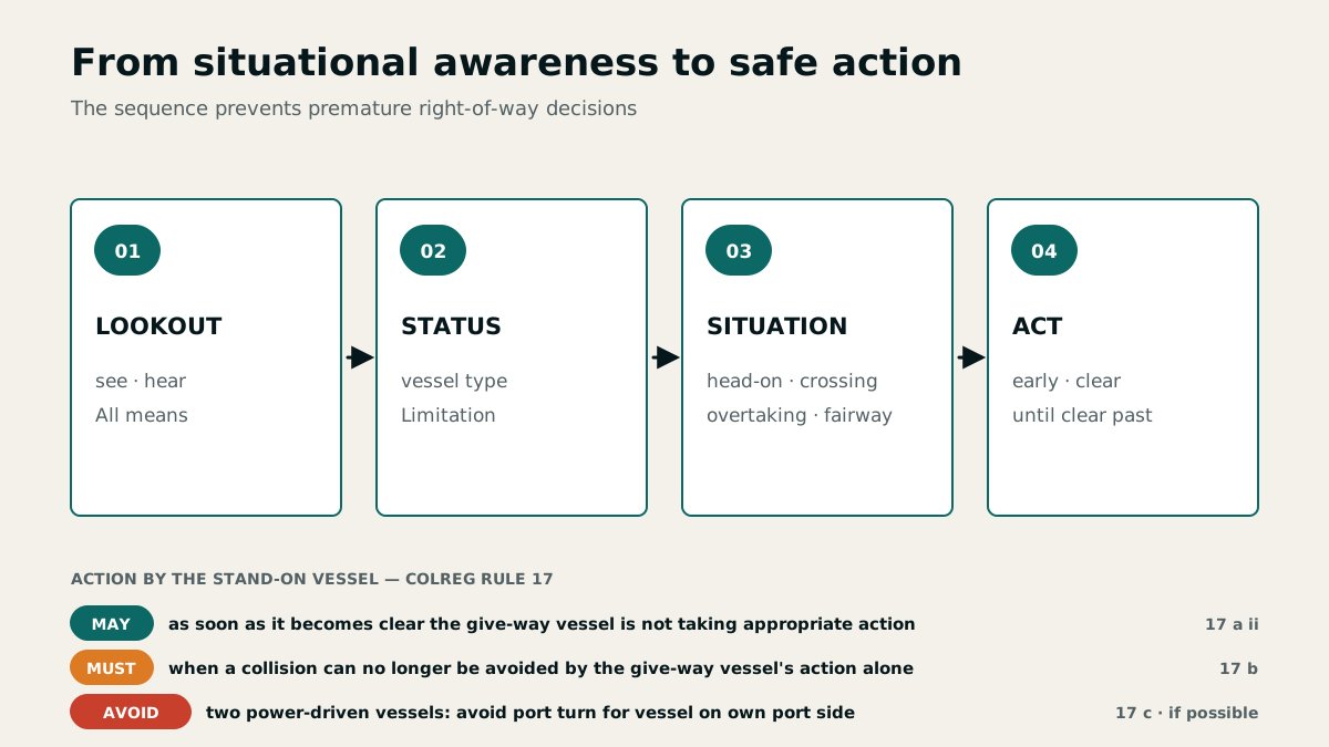
Collision regulations are not a collection of isolated right-of-way cases. They begin with lookout, safe speed and risk assessment and end only when the other vessel is finally past and clear.
Responsibility comes before right of way
The COLREGs require a proper lookout by sight, hearing and all available means appropriate to the circumstances at all times. Safe speed must allow the vessel to take proper and effective action and to stop within an appropriate distance, considering visibility, traffic, wind, sea state and manoeuvrability. No rule may be interpreted so as to force an obvious risk of collision.
The general duties extend beyond individual steering and sailing rules: every participant must protect the safety and flow of traffic and must not cause avoidable damage, danger, obstruction or nuisance. The ordinary practice of seamen and special circumstances may therefore require additional precautions.
A nearly constant compass bearing with decreasing range is the classic reliable indication of risk of collision. Give-way action must be early, substantial and readily apparent to the other vessel. Continue to monitor its effect until both vessels are finally past and clear.
The stand-on vessel initially maintains course and speed. If it becomes apparent that the give-way vessel is not taking appropriate action, the stand-on vessel may take action by the stand-on vessel alone. When collision cannot be avoided by the give-way vessel's action alone, the stand-on vessel must take the action that will best aid in avoiding collision.
The German regulations implementing the COLREGs apply on German maritime waterways and, in principle, to German-flagged vessels seaward of German territorial waters unless the law of foreign territorial waters provides otherwise. Anyone impaired by physical or mental limitations, alcohol or other intoxicants may neither command a vessel nor perform bridge or deck duties. Fixed limits also apply at 0.25 mg/l breath alcohol and 0.5 per mille blood alcohol.
In open water, responsibility is determined at the moment the vessels first come into sight of each other. A later change in their relative positions does not change the established duty to give way. Special circumstances may require departure from a rule to avoid immediate danger.
Vessel status and hierarchy
A vessel not under command (NUC) is unable to manoeuvre as required because of an exceptional circumstance, such as steering failure. A vessel restricted in her ability to manoeuvre (RAM) is limited by the nature of her work, for example when laying buoys, dredging, surveying, laying cables, clearing mines or conducting a particularly restrictive tow. By day, NUC is shown by two black balls and RAM by ball–diamond–ball in a vertical line.
A power-driven yacht keeps out of the way of vessels not under command, vessels restricted in their ability to manoeuvre, vessels engaged in fishing and sailing vessels. A sailing vessel keeps out of the way of NUC, RAM and fishing vessels; between sailing vessels, tack and windward position determine the duty. A vessel constrained by her draught must not be impeded in her safe passage.
Keep at least 1,000 metres clear of mine-clearance vessels. Safety zones around platforms, drilling rigs and similar installations generally extend 500 metres around the installation and must not be entered.
A motor yacht may also have to give way to another power-driven vessel, depending on the encounter. Keep clear of a vessel constrained by draught by altering course, speed or both early enough to preserve its safe passage.
Traffic separation schemes and restricted visibility
A traffic separation scheme divides a shipping route into one-way traffic lanes separated by a line or separation zone. Vessels proceed in the general direction of traffic flow, keeping to the right of the separation and using the full width of the lane. A vessel obliged to cross does so on a heading as nearly as practicable at right angles to the traffic flow. Vessels under 20 metres and sailing vessels may use the inshore traffic zone even when not proceeding to or from a port within it.
In a narrow channel, vessels under 20 metres and sailing vessels must not impede a vessel that can navigate safely only within that channel. In a traffic lane of a separation scheme, they must not impede power-driven vessels following the lane. Preserve the required room early. The inshore traffic zone lies between the coast and the landward boundary of the separation scheme.
In restricted visibility, both power-driven and sailing vessels must proceed at a safe speed adapted to the conditions. If a sailing vessel has an engine, keeping it ready is part of good seamanship. A vessel without radar that hears a fog signal apparently forward of the beam must reduce speed to the minimum at which she can be kept on course, take all way off if necessary, and navigate with extreme caution.
German Maritime Waterways Regulations: fairways and priority
On German maritime waterways, the COLREGs and the German Maritime Waterways Regulations apply together, with the more specific provision taking precedence. Fairways are laterally bounded or marked waterways, or on certain inland waterways the parts intended for through traffic. They are treated as narrow channels under the COLREGs.
Through traffic clearly follows the course of the fairway; under the usual interpretation, a deviation of up to about 10 degrees still counts as following it, while a greater angle constitutes crossing. A vessel using the fairway keeps as near to the outer limit on her starboard side as is safe and practicable. A vessel outside it must make clear that she is not using the fairway.
A vessel required to give priority must wait. Vessels entering, turning in, berthing or unberthing indicate in good time that they will wait until traffic in the fairway can proceed unobstructed. Priority applies only to vessels navigating in the fairway or following its course and never permits a collision to be forced.
Buoyage is interpreted from the designated direction of buoyage, irrespective of the vessel's direction of travel. A vessel proceeding down the Elbe past Cuxhaven and seeing buoy 32a to starboard is therefore looking at a port-hand fairway buoy; buoy 32 follows on the same side of the fairway.
The catalogue defines German maritime waterways as waters extending to three nautical miles seaward of the baseline, continuously laterally marked seaward fairways within the territorial sea, and specified inland waterways between their banks. The landward boundary is the coastline at mean high water or the seaward limit of inland waterways. Relevant official notices and port regulations also apply alongside COLREGs and the Maritime Waterways Regulations.
Sailing vessels following the fairway on nearly reciprocal courses both alter to starboard. If they are not clearly following the fairway, COLREGs govern their mutual give-way duties without endangering or impeding vessels with fairway priority. Observe COLREG give-way rules when crossing a buoyed shipping route. The duty to wait under German maritime waterway rules is legally distinct from giving way under COLREGs.
Special rules, notifications and protected areas
In the Kiel Canal, recreational craft may normally proceed only during daylight, not in restricted visibility and not under sail. Plan the passage so that a designated recreational-craft berth can be reached in time. A power-driven recreational craft may also set sails and may tow no more than one recreational craft.
Outside the fairway, the limit where bathing activity is evident and the shore is less than 500 metres away is 8 km/h. For Zone I of the Wadden Sea national parks outside special protection areas, the model answer states: do not leave the fairway between three hours after high water and three hours before the next high water; at other times, a maximum of 8 knots outside the fairway, and generally 12 knots within it.
Report an uncharted danger, such as a drifting container, as soon as possible to the Maritime Situation Centre in Cuxhaven, either directly or through a vessel traffic service centre or coast radio station. The Federal Bureau of Maritime Casualty Investigation (BSU) investigates causes and issues safety recommendations; it does not apportion blame.
Marine casualties include loss of a vessel, grounding or collision, death, a missing person or serious injury, environmental or property damage, and a specific danger to people, a vessel, offshore structures or the marine environment.
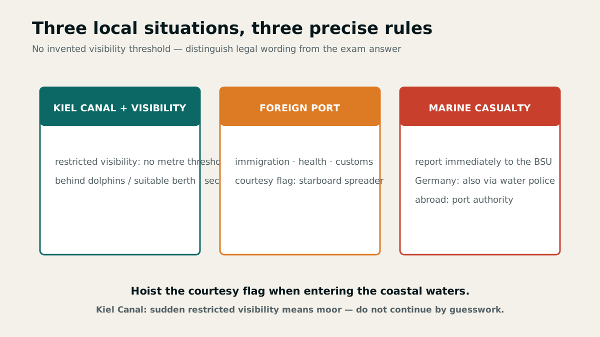
The catalogue treats the Kiel Canal and its approaches primarily as a transit route. Without a pilot, use is limited to the prescribed daylight transit hours. If visibility suddenly deteriorates during passage, recreational craft may secure behind the dolphins in passing areas or at suitable berths.
Chapter 10 · 1 questions
Baselines and internal waters
One line on the chart separates several legal zones. Understanding its direction makes internal waters and the territorial sea easy to distinguish.
What separates the baseline
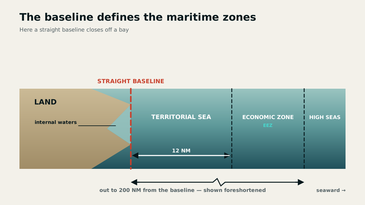
The baseline is the boundary between a state's internal waters and its territorial sea. It does not necessarily follow every indentation of the physical coastline but is shown on the nautical chart as a legal reference line.
Internal waters lie landward of the baseline. The territorial sea begins seaward and generally extends up to twelve nautical miles. The terms landward and seaward are the safest guide in examination questions.
From the chart to the applicable law
The line shown on the nautical chart allows the vessel's position to be assigned to a legal zone. Only then can the additional traffic, entry, environmental or conservation rules applying there be determined.
Baseline, coastline and fairway boundary are not the same. The baseline defines a state's maritime zones, buoys mark a fairway, and the coastline is the transition between land and water.
Chapter 11 · 7 questions
Local duties, ports and marine casualties
Local knowledge matters where general rules are insufficient: in canals, when entering foreign ports and after events that require immediate reporting.
Towing and fog in the Kiel Canal
If a recreational craft is overtaken by fog in the Kiel Canal, she must make fast as soon as possible in a siding behind the dolphins or at a suitable berth. Continuing cautiously by sight is not permitted under the canal's special rules.
A motorised recreational craft may tow only one recreational craft. The vessel being towed must be less than 15 metres long and the tow must be capable of at least 9 km/h.
Foreign ports, flag etiquette and bilge water
On first entering a foreign port, complete immigration, health and customs formalities. During flag hours, a German yacht in commission flies the national ensign from the stern staff; a sailing vessel with several masts may fly it at the masthead of the aftermost mast, but not from the backstay.
Oily bilge water may be discharged only under the strict conditions of MARPOL. If those conditions are not met, retain it on board and deliver it to a port reception facility.
Report a marine casualty without delay
A marine casualty must be reported without delay to the Federal Bureau of Maritime Casualty Investigation (BSU); when entering a German port it may also be reported through the water police, and abroad through the competent port authority. Reporting does not replace emergency action but takes place in parallel or immediately afterwards.
The report includes, among other things, place and time; vessel details including name, call sign, flag and MMSI; the master responsible; port of departure and destination; persons on board; personal injury and property damage; sequence of events; other vessels involved; weather; and any risk of marine pollution.
Chapter 12 · 13 questions
Documents, maritime zones and command responsibility
Maritime law depends on precise terms: documents, registration, flag rights, territorial sea and personal fitness each answer different questions.
Fitness to navigate and alcohol
No person may command a vessel or perform bridge or deck duties if physical or mental limitations, alcohol or other intoxicants impair safe performance. The prohibition therefore applies even below a fixed limit as soon as safe command or duty is no longer possible.
Irrespective of impairment, those duties are prohibited from 0.25 mg/l breath alcohol or 0.5 per mille blood alcohol; consuming an amount that leads to either value is also covered.
Flag certificate and ship's certificate
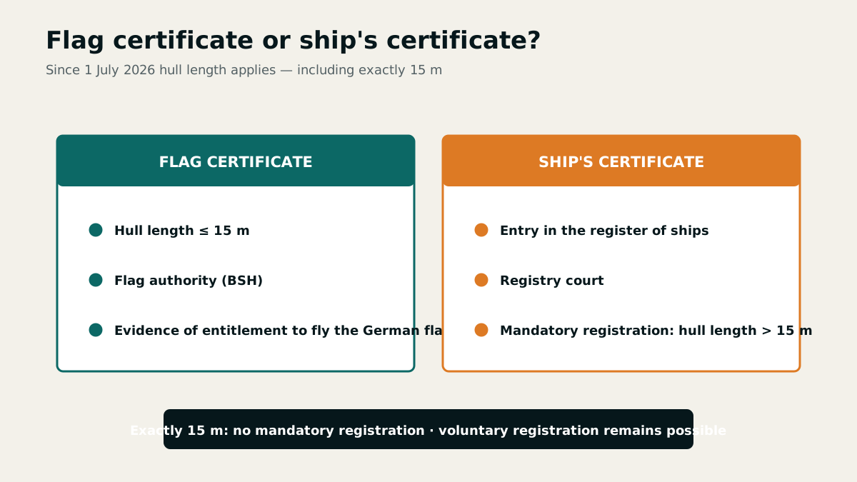
The flag certificate issued by the BSH proves the right and obligation to fly the German federal flag for vessels under 15 metres length overall that are not required to be registered. It is neither proof of ownership nor a certificate of competence.
The ship's certificate proves registration in the register of seagoing ships. It is issued by the registry court and is required from a hull length of 15 metres. Vessel length and issuing authority clearly distinguish the two documents.
Baseline, territorial sea and protected areas
The baseline separates internal waters from the territorial sea and is shown on nautical charts. The territorial sea extends seaward from the coastline at mean high water or from the baseline to a maximum breadth of 12 nautical miles.
The limits of protection zones I and specially protected areas within national parks are also shown on nautical charts. On entering the coastal waters of a host state, hoist its courtesy flag at the starboard spreader.
Public authorities, publications and MARPOL
The German regulations on safety at sea specify the information to be reported after a marine casualty. The master is responsible, or if prevented, another crew member and, where necessary, the operator. Maritime boards, by contrast, consider whether navigation bans or withdrawal of certificates of competence or licences are required.
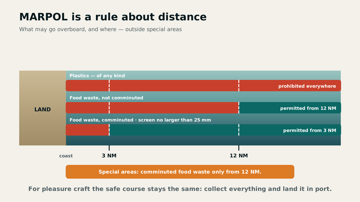
German water-sports safety guides provide legal information for recreational mariners. MARPOL also applies in principle to recreational craft. In special areas, plastics, synthetic ropes and nets, paper, rags, glass, metal and packaging material in particular must not be disposed of at sea.
Chapter 13 · 5 questions
MARPOL and environmental protection at sea
The safe default is simple: avoid discharge, retain waste on board and deliver it ashore. The legal check identifies areas where even narrow exceptions do not apply.
Purpose and application of MARPOL
MARPOL is intended to prevent pollution of the sea by ships and in principle also applies to recreational craft. It distinguishes substance groups such as oil, sewage, garbage and other pollutants because different equipment and discharge rules apply to them.
In practice, identify the substance first, then check the sea area and any applicable exception. A single distance from land is not a reliable answer for every substance.
European special areas
The Baltic Sea, North Sea and Mediterranean are European special areas under MARPOL. For recreational navigation, discharge of oil, sewage, garbage and other pollutants is generally prohibited there.
Garbage in particular is not disposed of at sea in these areas. The rule covers not only plastics but also paper, glass, metal, rags, earthenware and packaging material.
Preparing waste disposal in practice
The BSH brochure on reception facilities for oil, garbage and sewage lists facilities in German recreational-craft harbours. Consult it during passage planning whenever such waste may arise on board.
Separate waste on board, keep containers securely closed and plan capacity to reach the next reception facility. Good seamanship treats prevention and disposal ashore as the norm rather than relying on legal exceptions.
Chapter 14 · 21 questions
Air pressure, pressure systems and weather trends
A barometer reading alone is only a number. The isobar pattern, pressure tendency, depression track and the vessel's own movement turn it into a useful weather assessment.
Weather observation as a fixed routine
Wind is moving air caused by pressure differences between high- and low-pressure areas. A complete onboard observation records at least wind direction and force, atmospheric pressure, present weather, cloud cover and cloud type, supplemented as appropriate by sea state, current, temperature and humidity.
Atmospheric pressure is measured with a barometer or barograph in hectopascals, occasionally still in millibars. Record it at least every four hours together with time, position, wind and weather. Only a series of observations reveals the approach of a low, front or trough.
Isobars join points of equal atmospheric pressure and are commonly drawn at 5 hPa intervals. The closer they lie, the steeper the pressure gradient and, generally, the stronger the wind.
Wind around high and low in the northern hemisphere
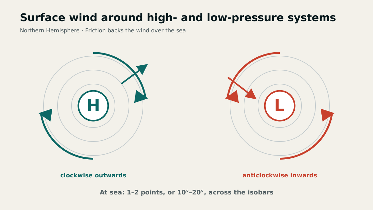
Near the surface in the Northern Hemisphere, air flows clockwise out of a high and anticlockwise into a low. Isobars near the centre of a high are often widely spaced, so winds there are generally light and variable.
Without friction, wind would flow almost parallel to the isobars. Over the sea, surface friction backs it anticlockwise, so it crosses the isobars out of a high or into a low at an angle of about 10 to 20 degrees.
Depressions form along the boundary between cold air from high latitudes and subtropical warm air. Fast-moving lows travel at about 30 to 50 knots, medium ones at 15 to 30 knots and slow ones at no more than 15 knots.
In the official low-pressure diagram, the marked wind directions are north-east, south, south-west, north-west and variable at the centre, in the order of the labelled points. More important than memorising the list is deriving each direction from the anticlockwise surface flow directed into the low.
Front passage, trough and pressure course
Ahead of a cold front, pressure often remains steady or falls only slightly; it reaches a minimum during passage and rises markedly behind the front. If a trough follows, the wind backs, pressure falls again, and wind and showers may strengthen to gale force.
Troughs typically form on the rear side of a low in deep cold air. During passage of a pronounced trough, the wind usually veers 60° to 90°; hurricane-force gusts are possible, especially on the rear side.
A pressure fall of 10 hPa in three hours indicates a severe storm. The vessel's own movement modifies the observed tendency: a vessel heading west towards the centre of an eastward-moving low will observe an apparently steeper pressure fall.
Combine the weather chart with the vessel's course
The isobar chart provides the pressure gradient and an initial wind direction. For a sound decision, relate the system's direction and speed to the vessel's position and intended course.
Sailing into a system can make change appear faster, while moving with it can mask a genuine development. Barometer trend, chart and vessel motion must therefore always be considered together.
Do not assume all clear after a front. Continue logging pressure, wind shifts, clouds and shower development until it is clear whether ordinary rear-side weather or a trough will follow.
Chapter 15 · 2 questions
Humidity, dew point and condensation
Fog and clouds begin with a simple relationship: how much water vapour the air contains and how far its temperature remains above the dew point.
Interpreting relative humidity correctly
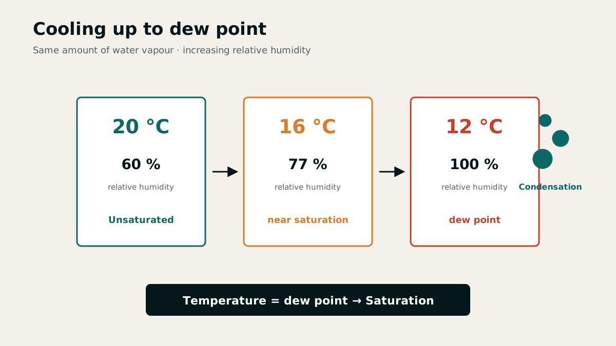
In marine weather information, humidity is usually given as relative humidity in per cent. It is the ratio between the water vapour present and the maximum possible amount at the current temperature.
Warm air can contain more water vapour than cold air. As the same air mass cools, its relative humidity therefore rises even without any additional moisture.
The dew point as the condensation threshold
The dew point is the temperature to which air must be cooled for it to become saturated with water vapour. Further cooling causes moisture to condense as dew, cloud droplets or fog.
The smaller the difference between air temperature and dew point, the less cooling is needed to reach saturation. For onboard decisions, that spread is therefore more useful than an isolated humidity value.
Chapter 16 · 16 questions
Fronts, clouds and thunderstorms
Clouds are not decoration. Their shape, height and sequence reveal the approaching air mass and the hazards associated with a frontal passage.
Air-mass boundaries and front types
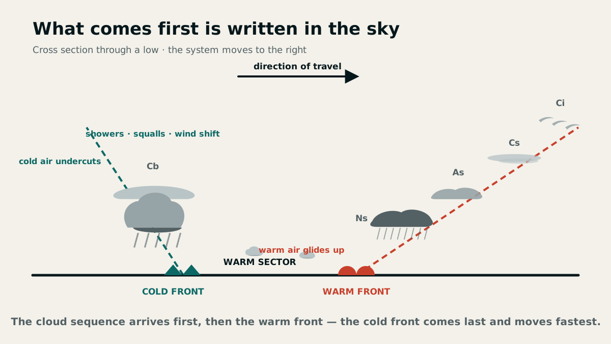
A front is the leading boundary of an air mass in its direction of movement and separates air masses of different temperature and humidity. The principal types are warm front, cold front and occlusion. In the official three-part diagram, 1 denotes the occlusion, 2 the warm front and 3 the cold front.
At a warm front, warm air glides gradually over colder air. At a cold front, denser cold air wedges beneath the warm air and lifts it more rapidly. In an occlusion, the cold front has caught up with the warm front and lifted the warm sector away from the surface.
Cloud families, heights and signs
Clouds are broadly described as convective or layered. The ten main genera are Cirrus, Cirrostratus, Cirrocumulus, Altostratus, Altocumulus, Nimbostratus, Stratocumulus, Stratus, Cumulus and Cumulonimbus.
In temperate latitudes, low clouds extend roughly from 0 to 2 km, middle clouds from 2 to 7 km and high clouds from 7 to 13 km. High clouds consist of small ice crystals. A halo around the Sun or corona around the Moon often indicates Cirrostratus, an advancing cloud sheet and deteriorating weather.
Altocumulus castellanus in the morning can herald a severe heat thunderstorm. Cumulonimbus with an anvil-shaped top identifies a mature thunderstorm cell; convective clouds, especially Cumulonimbus, already indicate increased gustiness.
Weather sequence from warm front to the rear of a depression
Ahead of and near a warm front, prolonged precipitation reduces visibility and the sky is generally overcast. In the warm sector, conditions are often hazy with moderate visibility, temporary breaks and rain.
Behind the cold front, visibility usually improves markedly while showers and strong gusts occur. This apparent contrast matters: good visibility between showers does not mean settled weather.
Squalls in showers can exceed the mean wind by more than 2 Beaufort forces, especially during cold-front passage and on its rear side. Continue to observe wind and pressure trends after the front has passed.
Thunderstorms as a distinct group of hazards
Thunderstorms bring gusts up to hurricane force, abrupt wind shifts, rain or hail with severe loss of visibility, and lightning. They can be especially violent when a cold front ends a spell of fine midsummer weather.
Forecasts mention thunderstorm squalls separately because they may reach gale or hurricane force even in a weak general wind field. Before the squall line arrives, the crew prepares reefs, secures loose equipment and hatches, rigs safety lines and ensures adequate manoeuvring room.
Chapter 17 · 34 questions
Wind, coastal effects and warning levels
Forecast wind applies to a standard height in open exposure. A vessel's motion, coastline, terrain and time of day can modify direction and strength more than the synoptic situation.
Beaufort, speed and wind direction
Wind force is stated on the twelve-point Beaufort scale; wind speed is stated in knots, metres per second or kilometres per hour. A moderate breeze is Beaufort 4, while strong-wind conditions cover Beaufort 6 to 7.
Forecasts and outlooks use eight directions in 45° steps; station reports use sixteen directions in 22.5° steps. For “northwest force 6”, the model answer gives west-northwest (WNW) to north-northwest (NNW) as the directional limits, a sector 45° wide in total around northwest. Gusts may be about 1 to 2 Beaufort forces above the mean wind.
A veering wind changes clockwise; a backing wind changes anticlockwise by at least 45°. Forecast charts generally refer to wind speed at about 10 metres above land or water.
True and apparent wind
On a moving vessel, an anemometer measures apparent wind speed: the vector sum of true wind and the wind created by the vessel's motion. The reading changes when the vessel luffs even if true wind speed remains constant.
Without instruments, estimate wind force from the sea-state appearance using the Beaufort scale. Approximate wind direction from the movement of wave crests, not from the alignment of one wave alongside the vessel.
Distinguish the measured and calculated quantities when changing course: apparent wind speed at the anemometer may change when luffing, while true wind speed remains unchanged if the weather is unchanged. The assigned examination question specifically asks about true wind speed.
Warning levels and gusts
Strong-wind warnings, or near-gale warnings, apply when Beaufort 6 to 7 is expected or continuing. From Beaufort 8, a storm warning or gale warning is issued. Hurricane warnings begin at Beaufort 10 because gusts exceeding Beaufort 12 may occur.
Station reports do not reproduce conditions over the open sea unchanged. Buildings and terrain can distort direction and generally reduce speed, but may accelerate the wind in funnelled locations.
Sea and land breezes through the day
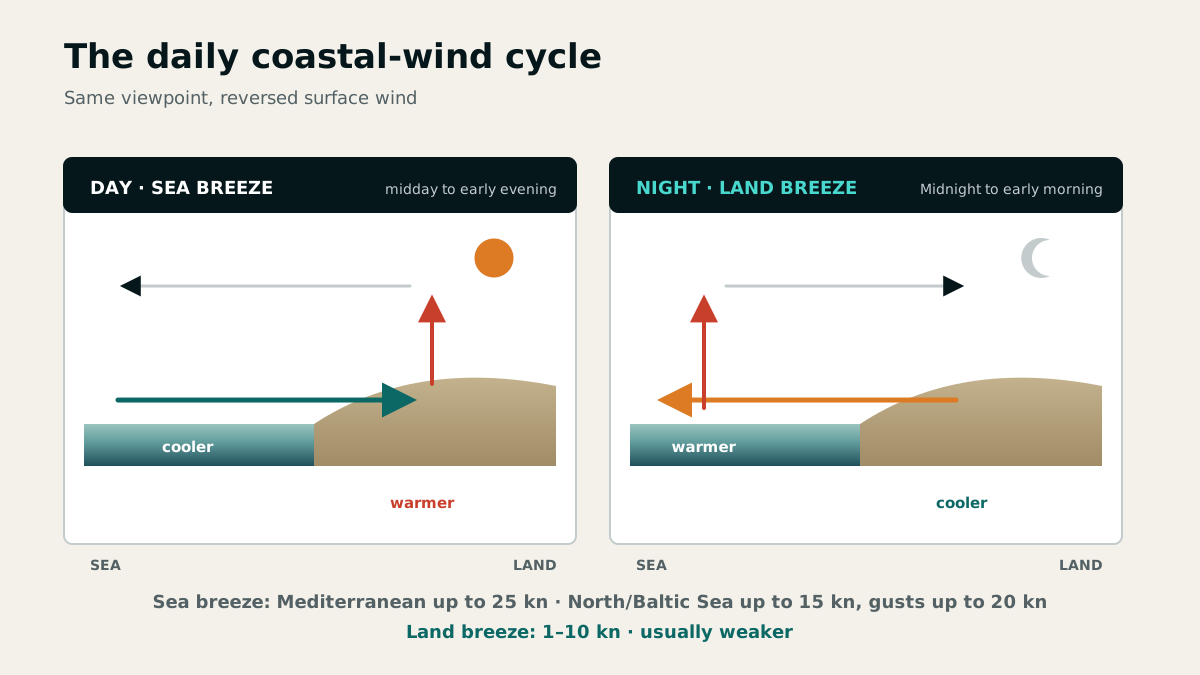
By day, land heats more quickly than water. Air rises over the land and a sea breeze flows in at the surface from the sea. It typically begins around midday and lasts until early evening; Cumulus over land may announce its onset.
In the Mediterranean, a sea breeze may reach about 25 knots or Beaufort 6; on the North Sea and Baltic it usually reaches 15 knots and occasionally 20 knots. It can alter the previous wind substantially in both direction and strength.
At night, land cools more than water. Air rises over the relatively warm water and a land breeze blows offshore. It occurs roughly from midnight to early morning and is generally weaker at about 1 to 10 knots or Beaufort 1 to 3.
Regional and local wind systems
In the Mediterranean, regional systems supplement the land-and-sea-breeze circulation: the Mistral, Sirocco, Bora and Etesian or Meltemi. The Bora is characteristic of the Adriatic and the Meltemi of the Aegean. Monthly charts and harbour or pilot guides show their seasonal frequency.
Narrow passages accelerate airflow through a jet or funnel effect. To windward of capes, wind often turns parallel to the coast and strengthens; in the lee of high islands, it may seem light and variable yet remain extremely turbulent because of downslope gusts.
Along steep coasts, onshore or coast-parallel wind may accelerate. Offshore wind can produce local katabatic gusts and variable directions. A sheltered harbour in offshore wind may therefore understate conditions at sea, while an exposed harbour in onshore wind is more representative.
Sea and land breezes, funnelling and headland effects can be represented only to a limited extent in marine forecasts. For unfamiliar coastal waters, consult port and cruising guides and monthly charts for the season's mean wind conditions. Observations in a harbour sheltered from an offshore wind must not be treated as measurements for open water.
Wind trend in the evening
A gradual easing of the wind in the evening often indicates settled development. An increase, by contrast, may herald strong winds, a gale and rain.
This is an observation, not a forecast on its own. Compare it with the barometer trend, advancing cloud, the official forecast and local effects.
Chapter 18 · 4 questions
Marine forecasts and weather information sources
A weather window is only as reliable as its source, currency and reception plan. Looking for frequencies only after conditions deteriorate is too late.
Structure of a marine weather forecast
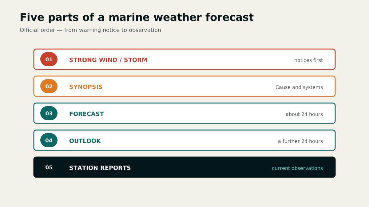
A complete marine weather forecast begins with strong-wind or gale warnings, describes the general weather situation and gives forecasts, outlooks and station reports. These parts cover different time horizons and must not be collapsed into a single average.
Large-scale reports can account for local effects such as land-and-sea breezes, funnels and capes only to a limited extent. Supplement the forecast with onboard observation and local knowledge.
Reception channels and official directories
Weather information can be received by broadcast radio, coast radio stations, vessel traffic service centres, NAVTEX, SafetyNET, weather fax, radioteletype, online services, telephone services and passage-advice services. At least two technically independent methods prevent total loss of information.
For European waters, broadcast times, frequencies and sea-area boundaries are listed in the German Nautical Radio Service handbook and Yacht Radio Service handbook; worldwide information is also provided by the Admiralty List of Radio Signals. Those publications also locate forecast areas such as Fisher.
Before departure, record the source, transmission time, frequency or channel and time of the next update. Internet access alone is not a robust reception plan at sea.
Chapter 19 · 17 questions
Wind sea, swell and breaking seas
Sea state is not judged by height alone. Origin, wavelength, direction, water depth and current determine whether a wave rolls gently or breaks dangerously.
Wave height, wavelength and characteristic height
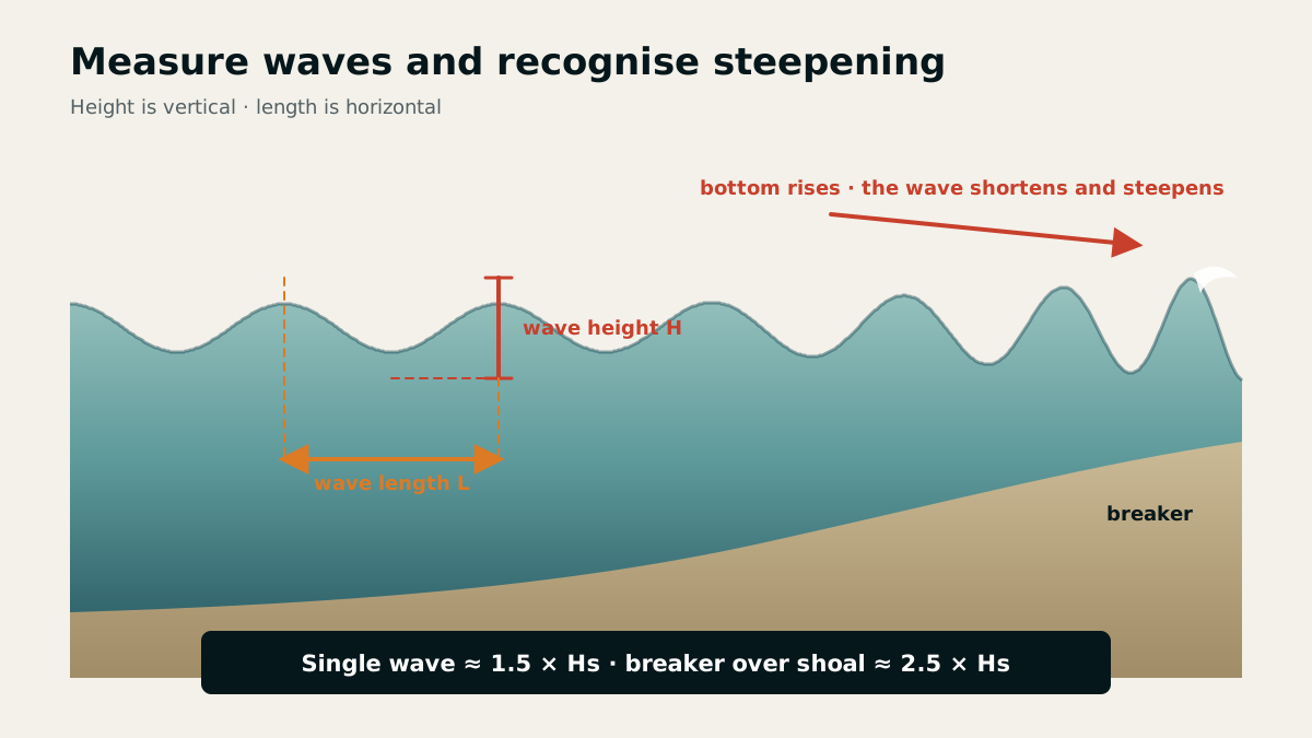
Wave height is the vertical distance from trough to crest; wavelength is the horizontal distance between two successive crests. They describe different properties and must not be confused.
Marine forecasts state the significant wave height: the mean height of the highest one-third of well-developed waves, not the extreme wave. Individual waves may reach about 1.5 times this value.
Wind sea, swell and cross sea
Sea state consists of wind sea and swell. Wind sea is generated by the wind at or near the observation point; its height depends on wind speed, duration and fetch, the unobstructed distance over which the wind acts.
Swell runs ahead of a weather system or persists after the generating wind has eased. A high swell may herald a distant approaching storm but does not by itself reveal the wind currently blowing at the observation point.
Cross sea forms when wind sea and swell arrive from different directions, for example ahead of or during a cold front, in a trough or near the centre of a low. Short, confused crossing seas may also occur in the lee of small islands.
Fetch, coast and shallower water
With offshore wind, the short fetch keeps seas near the coast smaller at first than in open water. Onshore wind has a long fetch all the way to the coast, so the sea there may be as fully developed as offshore.
As water shoals or waves pass over a bank, they steepen and may collapse as breakers or a breaking sea over the shoal. Such breaking seas may reach approximately 2.5 times the significant wave height.
Water depth and current also alter wavelength and height. Wind against current makes waves shorter and steeper; wind with current makes them longer and flatter.
Chapter 20 · 7 questions
Visibility and fog
Fog types are distinguished not by appearance but by the physical path to saturation. This explains their season, location and likely development.
Defined visibility terms
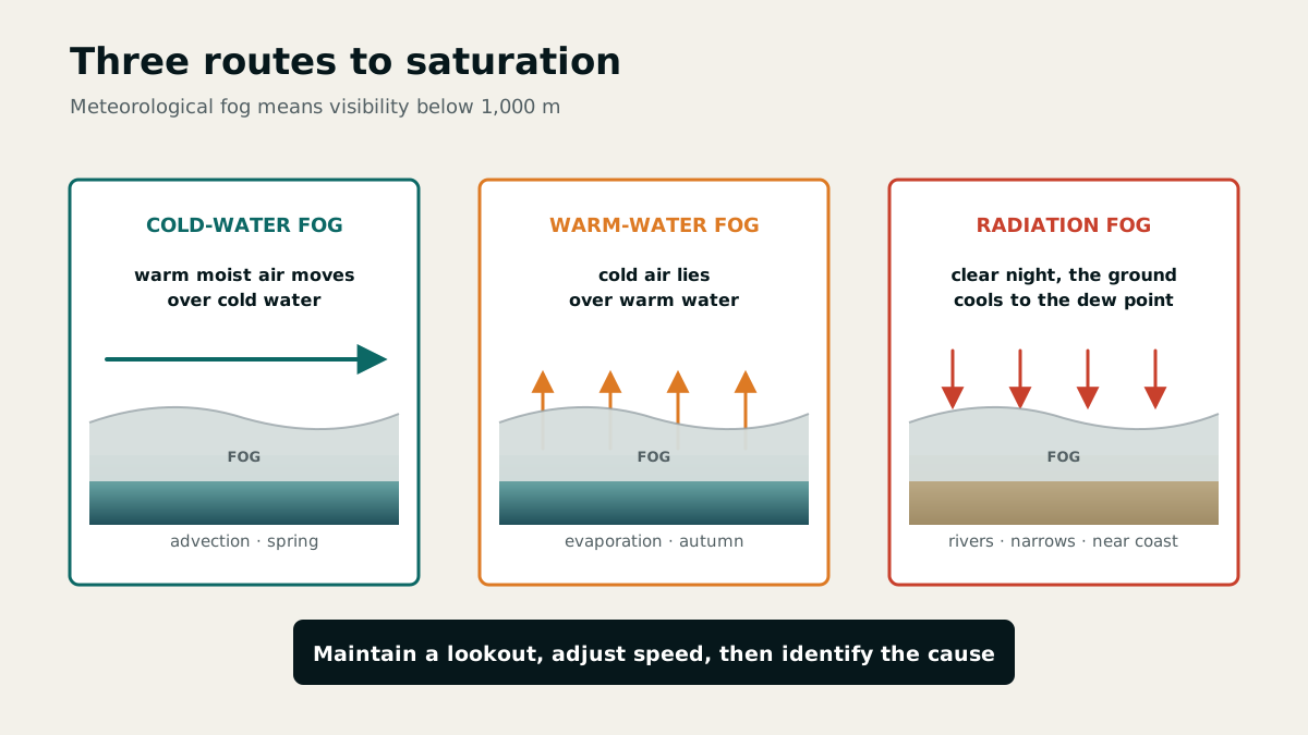
Fog is meteorologically defined as visibility below 1,000 metres. Mist or haze describes visibility above 1 km and up to 10 km, approximately 0.5 to 6 nautical miles.
Visibility can be reduced by condensation, precipitation, spray or transported particles. In the Mediterranean region, Sahara dust can greatly reduce visibility without fog.
Three routes to fog formation
Fog forms through an added moisture supply, mixing of moist air masses at different temperatures, or cooling to the dew point. The transfer of heat and moisture determines the fog type.
Advection fog forms when warm moist air is cooled below its dew point over a cold sea and is especially common in European waters in spring. Steam fog forms in autumn when cold air flows over much warmer water and becomes saturated by evaporation.
Radiation fog forms after sunset under clear skies as near-surface air over land cools. It is common near rivers and narrow passages and may drift towards the coast in a light offshore wind.
Onboard action when visibility falls
When visibility deteriorates, review position and course and adjust safe speed, lookout, sound signals, radar use and engine readiness without delay. In parallel, assess the cause from air and water temperatures, dew point, wind and the general weather situation.
An apparent clearing is reliable only after visibility and its trend have been checked repeatedly. Near coasts and currents, fog banks may have sharply defined edges and move rapidly.
Chapter 21 · 18 questions
Yacht construction, steering and stability
Materials, construction, steering and weight distribution determine the loads a sailing yacht can withstand and how it recovers from heel.
Assessing GRP, sandwich construction and steel
Gelcoat is the outer protective layer of a GRP component. It shields the laminate from water and weather, so damage should be sealed promptly before the laminate absorbs water. In sandwich construction, a light core such as balsa lies between two GRP skins, providing high stiffness and torsional strength at low weight while improving insulation.
Steel is strong, durable and readily repairable, but needs consistent corrosion protection and adds weight. A CE design category does not constitute clearance for the current weather; it describes the conditions for which the manufacturer designed the craft. Category B covers wind up to and including Beaufort 8 and significant wave height up to and including 4 metres.
Inspection follows the load path: check gelcoat and laminate for cracks, steel for corrosion, and skin fittings and deck fittings for movement or leakage. After grounding or a heavy impact, pay particular attention to the keel attachment, rudder, hull shell and bilge.
The CE category defines the operating area, wind force and characteristic wave height specified by the manufacturer for safe operation. The catalogue names are A Ocean, B Offshore, C Inshore and D Sheltered waters.
Steering, bilge pumping and emergency operation
With wheel steering, a chain in the pedestal transmits wheel movement to steering cables led over sheaves to the rudder quadrant. Cables, chain, sheaves and quadrant must therefore be inspected as one system. An emergency tiller must be carried, immediately accessible and familiar to everyone sailing on board.
A seagoing yacht should have two independent bilge pumps, one operable from above deck, and two buckets with lines. The strainer at the suction inlet prevents debris and blockage in the pump; inspect and clean it regularly. Manual pumps remain usable after power or engine failure.
LPG is heavier than air and can collect in the bilge as an explosive mixture. Cylinders belong in a locker drained overboard; close isolation valves before sleeping and when leaving the boat. Never store a petrol engine or outboard containing fuel in an unventilated space below deck.
The crew must be familiar with the emergency tiller so that it can be made ready in the shortest possible time.
Understanding stability as a pair of forces
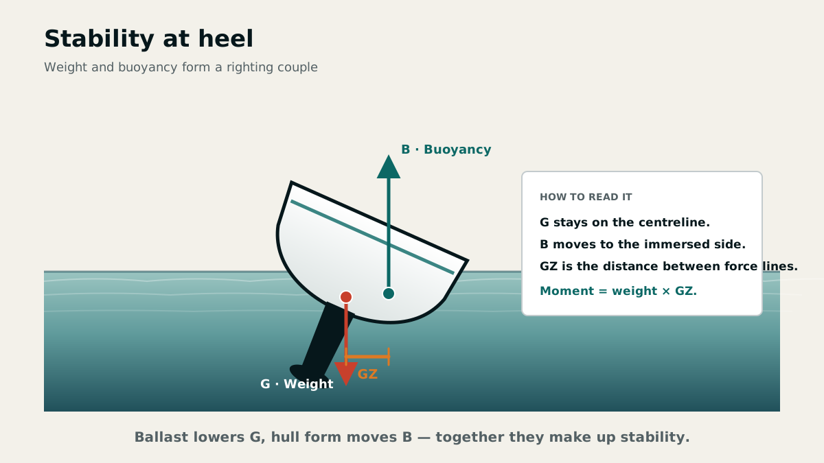
Stability is a vessel's ability to float upright and return upright after heeling. Weight acts downward through the centre of gravity G, while buoyancy acts upward through the centre of buoyancy B. As the yacht heels, B moves towards the immersed side; the horizontal separation between the two lines of action creates the righting moment.
Stability depends on hull form and weight distribution. Stores carried high, free surfaces in partly filled tanks and crew weight on deck raise or shift the centre of gravity unfavourably. Heavy weather adds dynamic loads from wind, sea state and especially breaking waves.
As heel increases, the effective lateral plane becomes smaller and leeway increases. At the same time the centre of effort moves to leeward and weather helm grows. Moving the traveller to leeward, easing the mainsheet and reefing early reduce heel and rudder load.
Chapter 22 · 36 questions
Rig, sail trim and heavy weather
A sound rig and correct trim turn wind into controlled propulsion. This chapter connects components, sail shape, reefing and heavy-weather tactics.
Standing rigging, running rigging and sail care
Shrouds and stays form the standing rigging; running backstays give additional aft support to a mast that is not masthead-rigged. Halyards, sheets and control lines form the running rigging. Inspect terminals, split pins, broken wire strands, chafe points, sheaves and attachments regularly and under load.
Dry wet sails, protect them from ultraviolet light, rinse off salt and repair damage promptly. Flogging loads the cloth, seams and fittings. A sail-repair kit includes a sailmaker's palm, needles, thread, wax, pliers and self-adhesive sailcloth; tools for cutting away an irretrievable rig include bolt cutters, a hacksaw with spare blades, spanners and pliers.
Coastal equipment includes a reefable mainsail, a reefable roller headsail or several headsail sizes, and a storm jib. A trysail replaces the mainsail in heavy weather and is set loose-footed; high-cut heavy-weather headsails keep breaking water from striking the sailcloth.
Battens shape the sail and keep the leech from folding in. Sail area is reduced steplessly by roller reefing: the headsail rolls around the forestay, the mainsail into the mast or the boom.
Read and trim profile
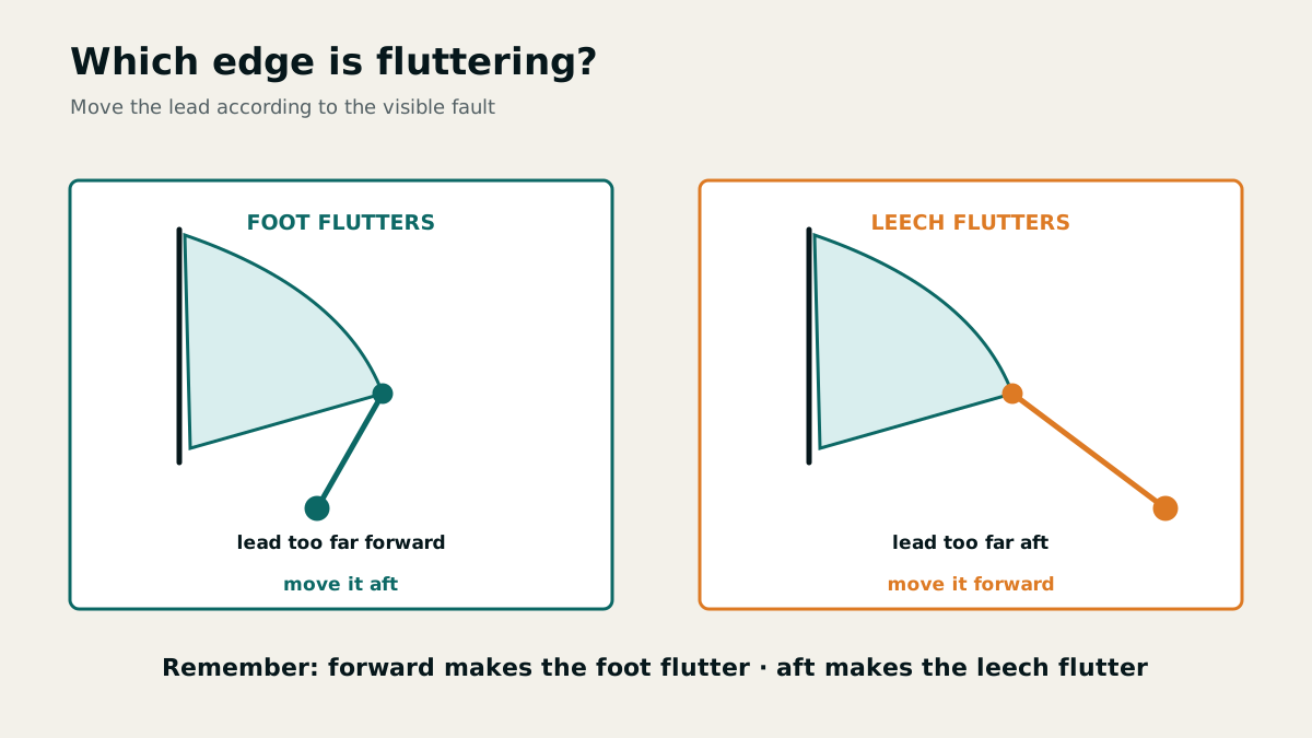
Tell-tales show the airflow. Wrinkles at the headsail luff usually indicate insufficient halyard tension. If the foot flutters, the sheet lead is too far forward; if the leech flutters, it is too far aft. The Cunningham adjusts mainsail luff tension, while the outhaul flattens or deepens the lower part of the mainsail.
In strong wind, flatten the mainsail: increase luff and foot tension, tension the main halyard and sheet appropriately, tighten the backstay and move the traveller to leeward. Increasing heel and rudder load show that depowering or reefing must no longer be delayed.
Apparent wind is the vector sum of true wind and the wind caused by the vessel's motion. It is stronger when sailing close-hauled and weaker on a broad reach. In a gust, true wind increases proportionally more; apparent wind moves aft and briefly permits a higher course when beating.
As heel increases, the yacht is set further to leeward by the wind. The reason lies below the waterline: the lateral plane — the side area of hull and keel meeting the water — becomes smaller, and with it the lateral resistance. Limiting heel therefore does not merely make the boat more comfortable; it also keeps her closer to the course steered.
When heel and weather helm increase sharply on the wind, that behaviour is called weather helm (German: Luvgierigkeit). The response is graded: traveller to leeward, ease the mainsheet a little — and if that is not enough, reef. Six items of running and standing rigging trim the mainsail: mainsheet, traveller, outhaul, Cunningham, main halyard and backstay tensioner.
Reefing, boom control and heavy-weather tactics
Before hoisting the mainsail, ease the mainsheet and vang and make sure the halyard runs clear. For slab reefing, support the boom, unload the mainsail, lower it to the reef tack, tension the new tack and clew, and only then tie the reef points loosely around the bundled sailcloth. Reef points carry no sail load.
A preventer guards against an accidental gybe and is led from the boom end well forward to a strong deck fitting. On broad reaches, the vang holds the boom down. In strong wind, heaving to or making a Q-turn avoids a dangerous gybe; the appropriate tactic depends on sea room, crew and yacht.
For thunderstorms, reduce sail early, secure loose objects, clip on the crew and avoid unnecessary contact with metal. After a dismasting: safeguard people, stop the engine, protect the hull from the flailing rig, recover or cut away the rig in a controlled manner, and only then prepare a jury rig.
If the mainsail tears below the lowest batten pocket, remove the bottom batten and reef the sail past the tear. That takes the load off the damage instead of tearing it further open.
Rafting up, and getting to know an unfamiliar boat
When boats of similar size lie rafted up or in a box berth, their masts knock together in a swell. They are therefore berthed offset, so the masts are not at the same height — or alternately stern-to and bow-to the pier. When a swell runs into the harbour, that is exactly what to check with your neighbours.
Anyone taking over an unfamiliar yacht learns her sailing characteristics not from the logbook but from manoeuvres: tacking, gybing, the Q-turn and the recovery manoeuvres, each at different speeds and sail combinations. After that the crew knows how the boat responds — before it matters.
Chapter 23 · 25 questions
Engine, onboard systems and electrics
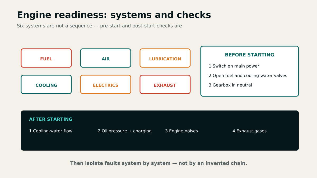
Engine operation is a chain of fuel, air, lubrication, cooling, electrics and exhaust. Faults are traced along this chain rather than by guesswork.
Starting, monitoring and fault isolation
Before starting, switch on the main battery isolator, open the fuel and cooling-water seacocks and place the gearbox in neutral. Immediately after starting, check cooling-water discharge, oil pressure, battery charging, noise, vibration and exhaust. Warning lights, rising temperature or changed exhaust colour require prompt investigation, not continued running under load.
If a diesel fails to start, check battery condition and cranking speed, fuel level and supply, air in the fuel line, preheating and the starter. If it stalls when gear is engaged, the propeller shaft or gearbox may be obstructed. If a saildrive cooling-water intake is blocked, careful alternation between ahead and astern may dislodge the obstruction.
If the normal stop control fails, stop a diesel by interrupting its fuel or air supply. This is an emergency measure; never put loose objects or hands near rotating parts. After shutdown, inspect for leaks, check the bilge and fluid levels, and close the appropriate valves.
If the engine stops when engaging gear, the catalogue lists not only a rope-fouled shaft but also a bent shaft and a stiff gearbox due to damaged gears, bearing failure or thick oil. Unusual noises, vibration, changed exhaust colour and visual or audible charging or oil-pressure warnings are early indications of trouble.
Fuel, propeller and corrosion protection
When refuelling, stop the engine, prohibit smoking and naked flames, and protect the filler against overflow. Oil-absorbent cloths and a large funnel with a hose limit pollution. Keeping a diesel tank nearly full reduces condensation; the water separator prevents entrained water from reaching the injection system.
Propellers are described by blade number and area, diameter and pitch. Fixed, folding, feathering and controllable-pitch propellers differ in drag and astern performance. A folding propeller may develop astern thrust only after a delay and at higher engine speed.
Sacrificial anodes protect metallic underwater parts electrochemically and must be renewed in good time. On a GRP yacht, for example, a zinc shaft anode protects the propeller. Stow a small petrol outboard with its tank and carburettor empty, and only on deck or in a locker ventilated overboard.
Prefer a pump with a filling nozzle to reduce pollution when refuelling. Avoid topping up from cans in wind and rough water where possible. The separator collects tank condensation that could otherwise cause starting problems; keeping a diesel tank nearly full reduces condensation during infrequent engine use.
When stopping, a folding propeller may unfold only at a relatively high speed and is less efficient than a fixed-blade propeller. Stow a small outboard with an integral tank only with tank and carburettor empty, on deck or in an externally ventilated locker, never below deck: residual petrol and escaping vapour form a readily ignitable mixture with air.
Onboard electrical system and consumption calculations
Electrical equipment depends on clean, tight, corrosion-free contacts. If a serviceable unit does not operate, check fuses, switches, negative return and plug connections systematically. Isolate the circuit before tightening contacts and clean them gently.
Power and current are related by P = U × I. Two 24 W loads together draw 4 A at 12 V; over ten hours they consume 40 Ah. Two 60 Ah batteries provide 120 Ah nominal capacity, while the official model answer assumes about 72 Ah of practically usable net capacity.
At minimum, carry spare impellers, V-belts, engine oil and sealing material. Organise tools and spares by sails, hull and rig, engine, electrics and hoses so that the correct repair route is immediately clear when a fault occurs.
A hand-pumped marine toilet has four controls: the seacock with the flushing hose for the sea water, the hand pump for flushing, the lever that shuts off the sea water supply — the pump then only empties the bowl — and the waste hose to the holding tank. Closing the seacock after use prevents the slow flooding that heel can cause.
The examination statement 2 × 60 Ah means two batteries rated at 60 amp-hours each, or 120 Ah nominal capacity. The model answer assigns about 72 Ah net capacity, citing a practical charge limit of about 80%. Know both catalogue values for this question; the stated net capacity cannot be calculated from 80% alone.
LPG such as propane and butane is heavier than air, sinks and may collect inside the vessel, for example in the bilge. It forms an explosive mixture with air.
Chapter 24 · 13 questions
Ropework, mooring and towing
Lines carry high dynamic loads. Material, lead, securing and chafe protection determine whether mooring and towing remain controlled.
Preserving line strength
Mooring lines, anchor warps and towlines must combine adequate breaking strength with elasticity. Knots can reduce strength by up to 50 per cent. Make connections with suitable splices, shackles or purpose-made eyes; secure cover and core against relative movement with a sewn whipping.
At fairleads and quay edges, protect lines with secured hose or robust chafe protection. Keep lines clear, with no feet or hands in a bight. Never step over a line under tension and always remain outside its snap-back zone.
Basic equipment includes at least four fenders and four mooring lines, plus spare rope, a heaving line, towline and anchor warp. Set fender height and prepare lines before the manoeuvre rather than improvising at the berth.
Alongside and in a box berth
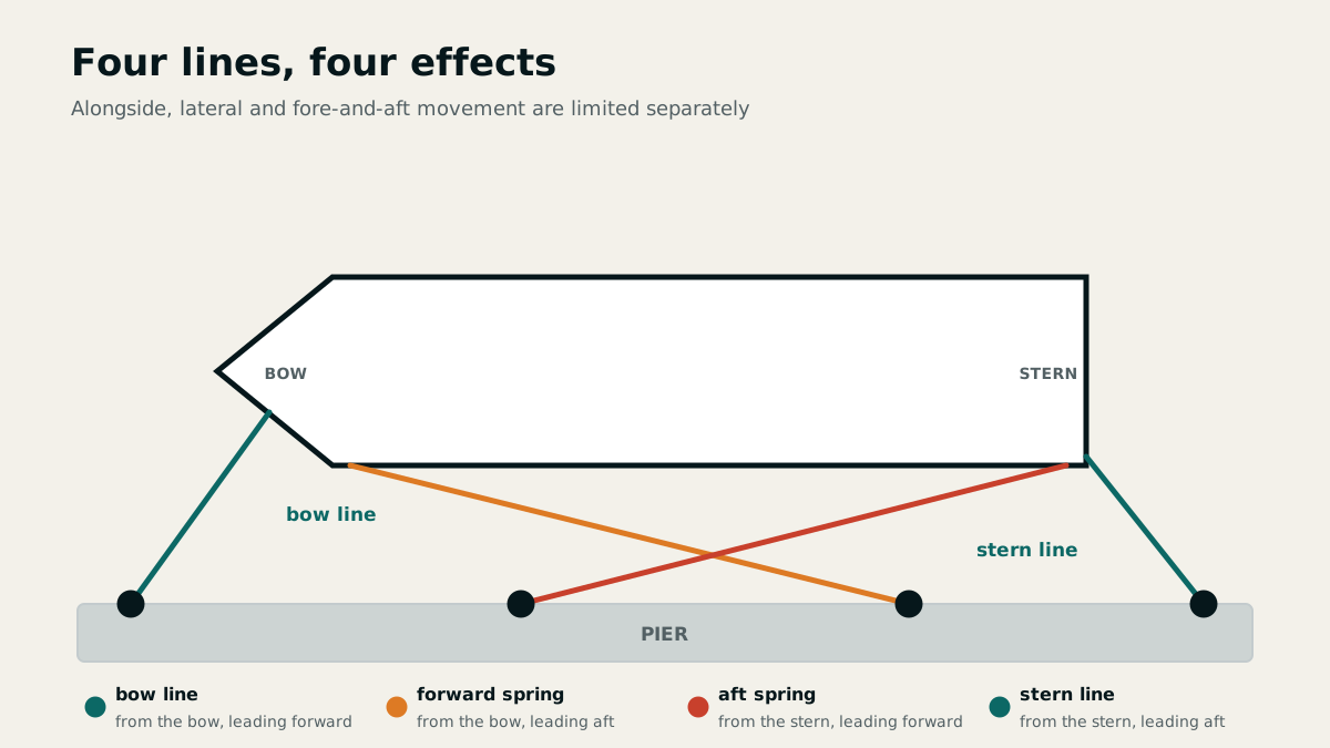
Alongside, the bow and stern lines restrain fore-and-aft movement away from their respective ends, while the forward and aft springs restrain movement along the quay. Lead lines as long and as nearly horizontal as possible. In tidal waters, allow for line length, changing water level and the possibility of taking the ground through the next high or low water.
For a box berth, prepare stern lines with eyes and place them over the piles as early as possible, windward first in a crosswind. Hang fenders on the exposed side. Where piles project, a fender board between two fenders spreads contact over a smooth surface.
Commands identify both the line and its purpose. Ease or make fast a line under control; do not try to hold it with body weight when engine thrust, wind or swell creates a high load.
Anchor warp and sea anchor
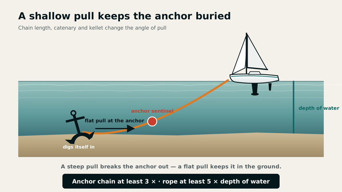
Chain helps an anchor dig in, reduces swinging radius, absorbs shock and resists seabed chafe better than rope. A three- to five-metre chain leader often connects anchor and warp. Secure the chain in the chain locker with a rope lashing that can be cut in an emergency.
Lower the anchor under control; a warp thrown overboard with it may foul the anchor and prevent it from digging in. A sea anchor increases drag in heavy seas and helps keep the bow or stern aligned to the waves.
Before any berthing or towing manoeuvre, assign crew, lines, fenders and strong securing points. Keep lines clear of the propeller; a bridle distributes towing loads across several adequately strong points.
Do not knot the anchor warp to the anchor, because knots can reduce its breaking load by up to 50%. The rope strop between chain and vessel allows the chain to be cut free quickly in an emergency.
Chapter 25 · 15 questions
Anchoring gear and anchoring manoeuvres
Safe anchoring starts with seabed, shelter and swinging room. Anchor type, scope, manoeuvre and holding checks follow.
Select anchorage and type of anchor
The anchorage must offer shelter from wind and waves, adequate water depth and swinging room. Allow for wind shifts, current, tidal range, traffic routes and neighbouring anchored vessels. Light-coloured water often indicates sand and good holding; dark seabed may indicate vegetation. Avoid rocky, heavily weeded or very soft muddy ground.
Lightweight anchors hold well in sand, mud and soft clay, moderately in hard clay, and poorly on rock, weed or very soft mud. A heavy stocked anchor may penetrate weed more effectively. Bruce, CQR, Danforth and D'Hone are among the high-holding-power anchors accepted in the official answer.
Several anchors of different types provide a replacement after loss, suit different seabeds and permit warping, tandem anchoring or lying to two anchors. The name alone is not decisive: size, a complete ground tackle and safe handling must also be suitable.
The catalogue lists patent anchors, stock anchors with a folding stock, grapnels with folding flukes and plough anchors as common types on recreational craft; three examples suffice in the examination.
Flat pull produces holding force
Chain, a chain leader and an anchor sentinel keep the pull on the anchor shank shallow, help the anchor dig in and absorb shock loads. As wind increases, pay out more chain or warp and, if appropriate, lower a sentinel. In confined space a sentinel can partly compensate for limited scope, but it cannot replace adequate swinging room.
Prepare the ground tackle and brief the crew before the manoeuvre. Approach slowly into wind or current, lower the anchor under control, and pay out chain or warp while moving gently astern. Exhibit the anchor ball or anchor light and record the position.
An anchor buoy marks the anchor's position, and its tripping line may help recover a fouled anchor. The line must not be so long that it endangers other vessels.
Maintaining constant control
After setting the anchor, feel the chain or warp for vibration and take repeated bearings of fixed landmarks. Distance from neighbouring vessels, soundings and a GPS anchor alarm supplement but do not replace visual checks.
The anchor watch allows for the swinging circle, changes in wind and current and changes in water level. A new wind direction may pull the anchor out of its original furrow, so reassess the position actively after a shift.
When weighing anchor, keep the bow above the ground tackle. Use the engine only to relieve the load, not the windlass to drag the vessel or tear the anchor free. If the anchor is fouled, use the tripping line or mark the position and devise a safe recovery plan.
Chapter 26 · 19 questions
Manoeuvres, current and large ships
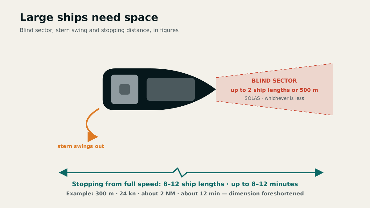
Sound manoeuvre planning combines wind, current, sail state, propeller effect and available room. Large ships add blind sectors and enormous inertia.
Planning ahead for harbour and heavy weather
Before berthing or leaving, assess wind, current and the escape route; assign crew tasks and prepare lines and fenders. A bow thruster moves the bow sideways at low speed but rapidly loses effectiveness as speed increases. When leaving an alongside berth, coordinated use of bow thruster, rudder and slow ahead power can move the yacht almost parallel away from the quay.
Strong onshore wind makes harbour entrances dangerous through breaking seas over shoals, cross seas and eddies in a cross-current. A lee shore reduces sea room and increases the risk of grounding. Begin the manoeuvre only when the entrance, water depth, engine reserve and abort route are all dependable.
Wind against current produces a short, steep sea. A following current increases speed over the ground but not the log reading through the water. A sea anchor or heaving to can stabilise the yacht; the choice depends on the vessel, sea room and sea state.
On a saildrive, the propeller is relatively far from the rudder, so it does not directly wash the rudder when starting, which can impair harbour manoeuvres. A bow thruster has a propeller in a tunnel at the bow and generates transverse thrust to turn the bow at low forward speed.
For weathering a storm in open water, the catalogue lists heaving to, running under bare poles with lines streamed astern, lying to a sea anchor, or actively sailing under storm canvas, steering around breaking seas where possible. With the correct line length, a sea anchor keeps the bow into the wind and reduces drift speed. A lee shore threatens stranding if the yacht cannot beat clear.
Alongside a pier in tidal waters, depth must suffice at low water or safe grounding must be assured. Mooring lines must accommodate the tidal rise and fall; with a larger tidal range the yacht must not be left unattended.
Person overboard as an action sequence
Raise the alarm immediately, throw flotation aids, maintain visual contact, mark the MOB position and begin the return manoeuvre. Start the engine and transmit a distress or urgency message as the circumstances require. The approach ends with a secure line connection, recovery and first aid.
The distance required for a close reach and luff-up manoeuvre depends on speed, wind, sea state, current, yacht type and sail area. Recovery aids include a secured boarding ladder, weighted foot loop, recovery tackle or lifting strop. Preventively, lifejackets, safety harnesses and jackstays are used early.
A marker buoy with a flashing light and the MOB key preserve the datum, the starting point for the search. They do not replace lookout: GPS marks a fixed position while the casualty continues to drift with wind and current.
Distance to large ships
Large ships have long stopping distances and respond slowly in a turn. Depending on type, loading and speed, stopping may require eight to twelve ship lengths and eight to twelve minutes; a 300-metre ship at 24 knots may need about two nautical miles.
With hard rudder applied, the stern initially swings to the opposite side and remains close to the old track for several ship lengths. The blind sector ahead may extend up to two ship lengths or 500 metres. A recreational craft must therefore never rely on being detected in time or on a large ship manoeuvring at short notice.
Close astern, suction, propeller wash and stern waves are hazardous. Radar and visual blind sectors add further risk nearby. An early, readily apparent course alteration, generous clearance and unambiguous communication are more effective than late avoiding action.
An approaching large ship has larger turning circles, longer stopping distances, restricted forward visibility and radar shadows in which a small boat may go unnoticed. Its bow waves and wind shadow can affect the recreational craft. A turn to starboard swings the stern to port, and a turn to port swings it to starboard.
Chapter 27 · 27 questions
Safety equipment, MOB and distress
Safety comes from serviceable equipment, rehearsed procedures and clear command. In an emergency: protect people, stabilise the situation and alert help.
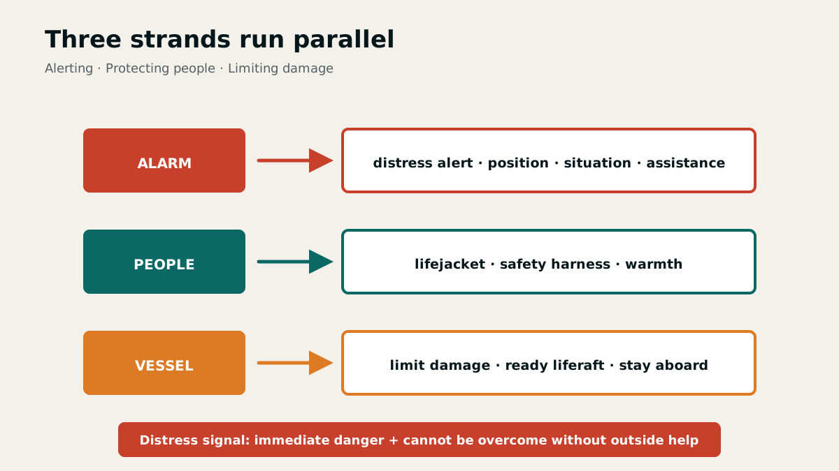
Check equipment and keep it accessible
Safety equipment for a coastal yacht includes independent bilge-pumping means, materials for stopping leaks, fire extinguishers, tools and spares, distress signals, hand torches, radio, ground tackle, first-aid equipment, a radar reflector and lifesaving appliances. Each person needs a suitable lifejacket and safety harness; a liferaft, lifebuoy with day-and-night signal and jackstays complete the system.
Service labels or certificates show maintenance dates for liferafts, automatic lifejackets and fire extinguishers. Keep equipment dry, protected from corrosion and accessible without dismantling. A passive or active radar reflector mounted high and securely improves radar detection.
Select distress signals for the required range and situation: red hand flares and rockets, orange smoke, a signal pistol, sea-dye marker, flags N over C, a signalling lamp and an EPIRB. Distress signals may be used only in grave and imminent danger that cannot be overcome without outside assistance.
The catalogue names the BSH publication “Safety at Sea and in Coastal Waters: Rules of Care for Recreational Boaters” and “Safety on the Water: A Guide for Recreational Boaters” from the Federal Ministry of Transport, Building and Urban Development named there. Such guidance is also used when assessing recreational boating accidents.
Fight fire and leak systematically
Firefighting equipment includes ABC dry-powder extinguishers, where appropriate CO₂ extinguishers for enclosed engine spaces, a bucket, fire blanket and an extinguisher access port. Mount extinguishers ready for use and readily accessible near machinery, galley or heating equipment; keep CO₂ extinguishers outside the vessel's interior because leakage may cause suffocation. Observe the inspection date on the label and protect against moisture and corrosion. Close openings, isolate fuel and electrical power, operate the extinguisher at the seat of the fire and attack from below and in front. Use the fire blanket; bucket water is for solid-material fires, never burning liquids.
For a leak: raise the alarm, reduce speed, start pumps, locate the ingress and stem it with onboard materials. Shifting weight may lift the damaged area above water; reachable shallow water may permit a controlled grounding. If the water level continues to rise, transmit a distress alert and prepare lifejackets and the liferaft.
Grounding and heavy impacts can cause hidden damage to the hull shell, keel or rudder. Reinspect the bilge, structural members and steering even if no water ingress is initially visible.
Hull damage after grounding, a hard berthing impact or collision may cause danger of sinking. If water continues rising despite damage control, send distress signals and a radio message, activate the radar transponder where available, put on lifejackets and prepare the liferaft. If possible, head for calm shallow water and ground the vessel.
Abandoning the vessel and recovering people
Abandon a sinking vessel as late as safely possible: she offers more protection, supplies and visibility than a liferaft. Before transferring, put on lifejackets and warm clothing, take warm fluids, and pass over water, provisions, signals, an EPIRB, a search-and-rescue radar transponder and a handheld VHF radio.
During helicopter rescue, let the winch wire hang free and never secure it to the vessel. With an open rescue strop, clip the karabiner first, pass head and both arms through the strop, press the arms down and clasp the hands. Follow the aircrew's instructions.
Supervise seasick crew in the cockpit and secure them against falling overboard. Replace fluid losses with water, encourage looking towards the coast or horizon and provide suitable tasks. Adjust watches and workload. A VHF radio may be used in an emergency without the relevant certificate.
The search datum for a person overboard can be marked with a flashing marker buoy and the MOB button on a satellite navigation receiver. Use both promptly where available.
In distress, remain calm, act deliberately, send a distress alert and activate a radar transponder where available. Put on a safety harness, lifejacket and warm clothing and prepare the raft. Stay aboard as long as possible: the vessel offers better survival prospects and is easier to locate; boarding and remaining in a liferaft may be difficult. Distress signals are given on the skipper's orders once distress has been established.
Person overboard: secure, approach and recover
Prevention means wearing and clipping in safety harnesses and ensuring the crew knows the attachment points. A jackstay is a taut wire, webbing strap or strong line beside the toe rail between cockpit and foredeck, used for clipping in a safety tether.
Immediately shout “Person overboard!”, throw flotation aids and assign a lookout to keep the person in sight. Start the engine, begin the MOB manoeuvre and send a distress message; deploy a flashing marker buoy and press the MOB button where available. Search and visual contact are followed by approach, an initial line connection, prompt safe recovery aboard, first aid and care.
Depending on the yacht, recovery aids include a movable secured boarding ladder, possibly the mainsheet, a weighted foot loop, recovery tackle, a small sail to scoop the casualty, a lifting strop or a dinghy. Completing the approach manoeuvre does not itself get the person on deck; prepare the recovery equipment.
Chapter 28 · 10 questions
Passage preparation, crew and onboard routine
A safe passage begins before departure. Preparation, briefing, logkeeping and onboard routines create reserves before weather or machinery demand them.
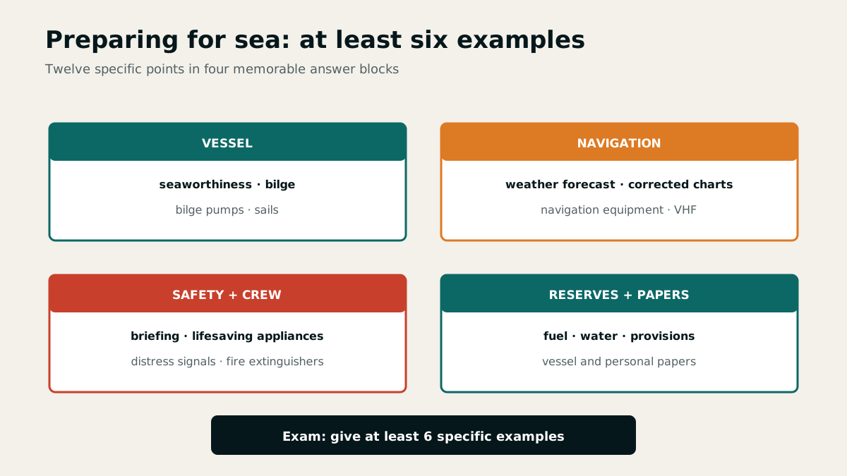
A complete pre-departure inspection
Before departure, check seaworthiness, fuel, water and provisions, weather, corrected navigational documents, engine, electronics, bilge, pumping arrangements, extinguishers, lifesaving appliances, distress signals and vessel and crew documents. Stow loose equipment and secure hatches and valves in the condition required for operation.
Organise tools and spares by rig, hull, engine, electrics and hose systems. Keep lashings, small cordage, tape, spare shackles, openers, a rigging knife and combination pliers immediately accessible. Clean antifouling only at equipped wash-down facilities and collect contaminated water and debris.
When taking over an unfamiliar yacht, test her engine and sailing behaviour, reefing system, steering, handling astern, stopping characteristics and emergency controls in sheltered water. Experience from other boats is no substitute for a briefing.
Brief the crew before action is required
Everyone is shown the lifejackets, safety harnesses, liferaft, distress signals, bilge pumps, seacocks, marine toilet, gas system, extinguishers, engine, electrics, radio, MOB button, ground tackle and emergency steering. The briefing covers location, operation and typical errors and ends with a short check-back or demonstration.
Practise the marine-toilet sequence: open the inlet, flush and pump, close the inlet, pump the bowl dry and close all seacocks. Incorrect operation can flood the vessel, so more than one person must be able to operate the pumps and valves.
Adapt the watch plan, roles and limits to experience and weather. Treat fatigue, cold and seasickness as safety factors before they lead to an error.
Every crew member must know the location and operation of all pumps and valves so that anyone can use them when needed.
Logbook as an ongoing situational picture
The logbook records crew and duties, the start and end of the passage and, at suitable intervals, position, course, speed, current, weather and atmospheric pressure. It also records manoeuvres, unusual events, damage and significant decisions.
Make entries promptly, legibly and with a time. They support navigation and watch handover and document the information on which the master based a decision.
At every watch handover, pass on course, hazards, weather trend, traffic situation, sail plan and alarm procedures. The logbook thereby becomes an active command tool rather than merely an archive.
Chapter 29 · 24 questions
Motor-yacht construction, steering and stability
Motor yachts combine hull form, propulsion and weight distribution into very different handling characteristics. Understanding these relationships reveals limits and damage earlier.
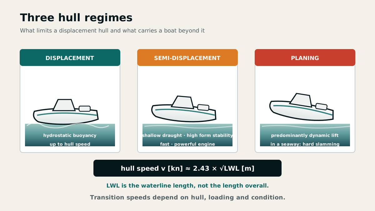
Materials, GRP and CE design categories
Hulls are commonly made of glass-reinforced plastic (GRP), steel, aluminium, waterproof-bonded plywood or solid wood. Gelcoat is the outer protective layer of a GRP component. Repair damage promptly because the laminate beneath absorbs water. Sandwich construction laminates a stiffening core, such as balsa, between two GRP skins, providing stiffness, torsional rigidity, low weight and good insulation. Steel is reliable and durable with high strength, but is heavy and susceptible to rust.
CE design categories A to D describe the conditions for which the manufacturer designed the craft, including wind and wave loads. Category B covers wind up to and including Beaufort 8 and significant wave height up to and including 4 metres. It is not an invitation to depart in those conditions.
After grounding or a heavy impact, repeatedly inspect the hull shell, keel or drive, rudder, skin fittings and bilge. Minor gelcoat damage may conceal a larger structural problem or admit water to the laminate.
The CE category defines the operating area, wind force and characteristic wave height specified by the manufacturer for safe operation. The catalogue names are A Ocean, B Offshore, C Inshore and D Sheltered waters.
Displacement, semi-displacement and planing hulls
A displacement hull remains supported by displacement and is limited by hull speed, which increases with the square root of waterline length. With sufficient power, a planing hull rises partly out of the water and exceeds the displacement limit, but requires high power and responds more harshly in a seaway.
A semi-displacement boat has shallow draught, very high form stability and achieves high speed with a powerful engine. Trim is the difference between forward and aft draught: deeper forward means trim by the bow, deeper aft means trim by the stern; equal draughts mean an even keel. Sideways inclination is heel.
In heavy seas, heading relative to the waves and speed determine impact loads. A fast craft turning at speed may develop a strong heeling moment. Reduce power before impacts overload the structure, propulsion or crew.
Steering, bilge pumping and emergency operation
Wheel movement is transmitted through chain, steering cables and sheaves to the rudder quadrant. Inspect the entire load path for play, corrosion, broken wire strands and loose attachments. A suitable emergency tiller must be accessible without first moving tools or stores.
Provide two independent bilge pumps, one operable from above deck, and two buckets with lines. Manual pumps remain usable during electrical and engine failure. The strainer at the suction inlet keeps debris out and prevents pump blockage; inspect and clean it regularly.
LPG sinks into low spaces and can form an explosive mixture. Hatches, seacocks, fuel system, gas shut-off, steering and bilge pumping therefore belong in every inspection round before departure.
Stability: shape, weight and righting moment
Stability is the ability to float upright and return from a heel. In calm water it depends on hull geometry and the distribution of equipment, crew and ballast. Side wind, towline pull and turning at speed create heeling moments. Heavy weather adds wind and sea, particularly breaking waves.
The centre of buoyancy F represents the mass of displaced water; buoyancy acts vertically upwards there. The centre of gravity G represents the mass of vessel, equipment and crew; weight acts downwards there.
When the vessel heels without movement of its centre of gravity, F shifts towards the immersed side. The lines of action of buoyancy and weight become separated by a horizontal lever arm. The resulting couple creates a righting moment: weight × lever arm.
Chapter 30 · 13 questions
Propeller effects and large ships
At low speed, motor yachts react strongly to propeller action, wind and current. Near large ships, suction, blind sectors and long response distances must also be considered.
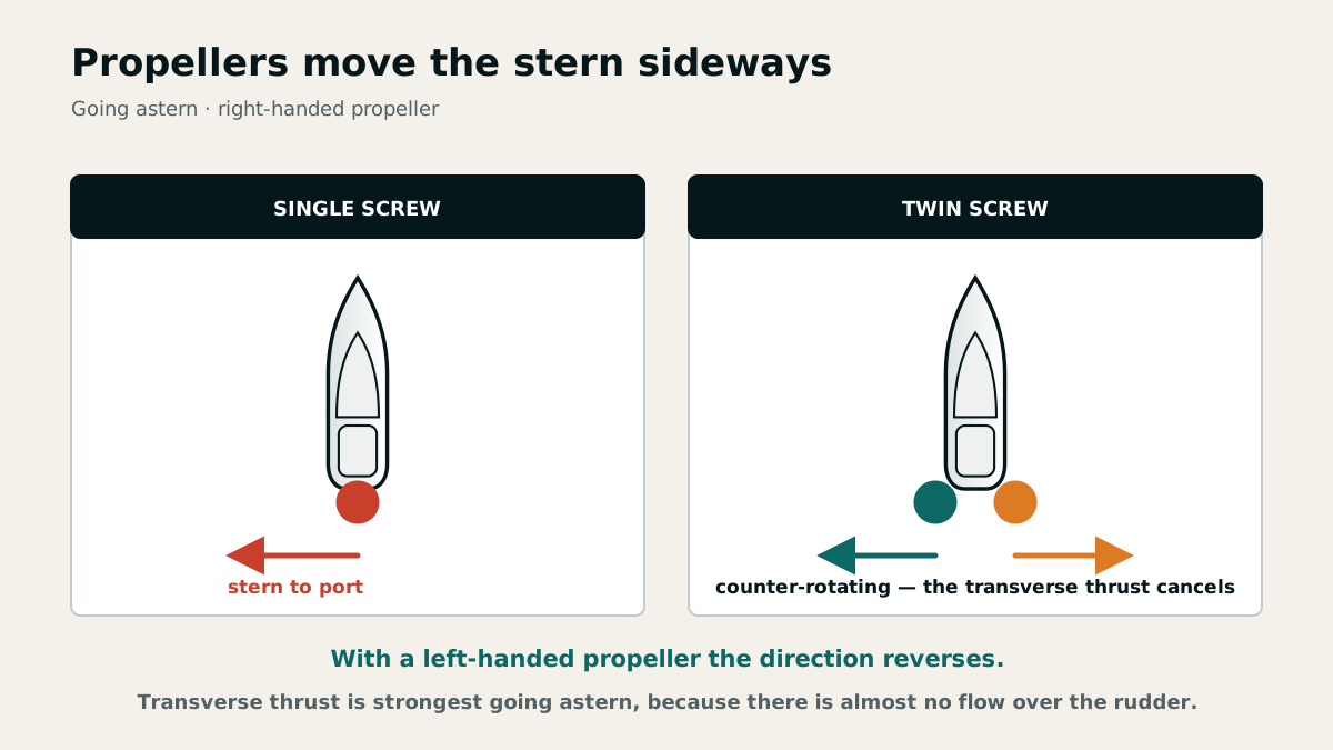
Transverse thrust and twin-screw propulsion
Transverse thrust is the propeller's sideways displacement of the stern, most pronounced when going astern with little headway. A right-handed propeller normally walks the stern to port astern; a left-handed propeller walks it to starboard. Hull form, propeller position and water flow affect its strength.
On twin-screw vessels, the propellers usually turn outwards. Their opposing transverse effects largely cancel in normal operation, while running one engine ahead and the other astern turns the vessel in a confined space. Rudders assist once sufficient water flows over them.
A bow thruster works best at little or no headway and for short periods. It supplements the main engines but does not replace planning for wind and current. Continuous operation may cause overheating or discharge the batteries.
A propeller is described by four figures: the number of blades, the size of their area, the diameter and the pitch — the distance it would travel in one revolution. Pitch and diameter together decide whether the engine reaches its rated speed or labours under load.
Trim, visibility and the outside helm
Trim is the difference between forward and aft draught. Sideways inclination is heel. Loading affects acceleration, forward visibility, hull resistance and propeller inflow. Excessive bow-down trim can cause water to be shipped; excessive stern-down trim can delay planing and obstruct the view over the bow.
Use the outside helm in restricted visibility to hear sound signals and during close manoeuvres for better all-round vision. Change helm position only after course, speed and responsibility have been handed over unambiguously.
Fenders, lines and people must remain visible from the helm. Communicate with the crew using short commands agreed in advance.
Keeping large ships clear early
A large ship may require eight to twelve ship lengths and eight to twelve minutes to stop. With hard rudder applied, her stern swings to the opposite side and initially remains near the old track. The blind sector ahead may extend up to two ship lengths or 500 metres.
A small craft may disappear behind structure and waves in a radar or visual blind sector. A radar reflector mounted high helps but provides no guarantee. Choose course and distance so that safety does not depend on the large ship detecting the craft or manoeuvring at short notice.
Immediately astern, suction, propeller wash and stern waves are hazardous. In a turn, also keep clear of the stern-swing area. Early and readily apparent action is the only reliable communication.
An approaching large ship requires larger turning circles and longer stopping distances; visibility from its bridge is restricted, particularly ahead. A small boat may go unnoticed in a radar shadow and be affected by its bow waves.
Chapter 31 · 33 questions
Engine systems, fuel and electrics
On a motor yacht the propulsion system is primary safety equipment. This chapter treats diesel and petrol engines, cooling, exhaust diagnosis, electrics and propellers as one system.
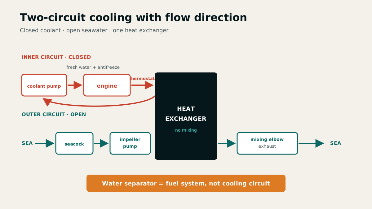
Operating diesel and petrol engines safely
A diesel compresses intake air until its heat ignites the injected fuel. In a petrol engine, a spark plug ignites the petrol-air mixture. Diesel fuel presents less fire risk and consumption is lower; petrol engines also have an explosive mixture and an ignition system sensitive to damp and water. Ventilate the engine space and bilge before starting a petrol engine.
Before starting, switch on the main battery switch, open fuel and cooling-water valves, select neutral and check coolant level in a two-circuit system. While running, monitor cooling-water flow, oil pressure and temperature, coolant temperature, speed and battery charging. Unusual noises, vibration, discoloured exhaust and visual or audible warnings indicate faults. After shutdown, close fuel and seacock valves and switch off the main battery switch.
Two-circuit cooling connects a closed internal fresh-water circuit with its own coolant tank to an open seawater circuit through a thermostatically controlled heat exchanger. Only fresh water circulates through the engine; additives such as antifreeze can be used. This prevents deposits from outside water. Thermostatic control brings the engine to operating temperature sooner and keeps that temperature constant.
Use warning signs as a diagnosis
For low oil pressure the catalogue lists a blocked sump strainer, low oil level, blocked oil filter, faulty oil pump, pressure valve or gauge. A charging warning can result from disconnected, oxidised, loose or broken wiring, a failed V-belt, regulator or alternator. Investigate warnings immediately.
Black exhaust indicates incomplete combustion: a cold engine, dirty air filter, poor fuel, incorrect injection-pump setting or overload. For white exhaust, the catalogue expects evaporating water, such as condensation in a cold exhaust, a cracked cylinder head or failed head gasket. Blue exhaust comes from burning or evaporating lubricating oil: too much oil in a two-stroke fuel mixture, or excess oil or defective oil-control or piston rings in a four-stroke engine.
An empty diesel tank admits air to the fuel system and requires bleeding. A sudden loss of engine speed may result from fuel starvation, a clogged filter, water contamination, blocked tank vent or fouled propeller. For overheating, reduce load and check cooling-water discharge, intake, impeller and circulation.
If the engine fails to start, check fuel quantity, shut-off valve, hoses, filter and fuel pump in sequence; on a petrol engine also check the carburettor. Running a diesel tank dry admits air to the lines and injection pump; refuelling alone is insufficient and the system requires bleeding. Deposits and condensation can cause further difficulties.
On a saildrive, a sudden temperature rise without a mechanical fault may result from plastic film, bags or vegetation blocking the cooling-water intake. The catalogue suggests alternating forward and reverse several times to dislodge them. If speed drops abruptly and the engine stops when throttled back, a line, rope or sheet of material may be fouling the propeller.
Potential engine damage or piston seizure may be indicated by insufficient coolant, steam bubbles in the coolant sight glass, overheating, low or falling oil pressure, insufficient or unsuitable oil, falling speed, a trembling tachometer needle or knocking.
Gearbox, propeller and onboard electrical system
The marine reversing gearbox engages and disengages the propeller, reverses shaft rotation and reduces engine speed. A single-lever control combines throttle and gear selection; a twin-lever control separates them. Before manoeuvring, confirm that the neutral detent and direction of operation are unambiguous.
Propellers are described by blade number and area, diameter and pitch. Incorrect pitch, fouling or damage may overload the engine. Keep shaft and propeller clear of lines; isolate the engine and ignition before working on them.
Batteries supply engine starting, domestic loads and, where fitted, the bow thruster. Charging may produce explosive hydrogen gas: ventilate, exclude ignition sources, and observe correct polarity and charging method. Consumption follows P = U × I; two 24 W loads consume 40 Ah at 12 V over ten hours.
The examination statement 2 × 60 Ah means two batteries rated at 60 amp-hours each, or 120 Ah nominal capacity. The model answer assigns about 72 Ah net capacity, citing a practical charge limit of about 80%. Know both catalogue values for this question; the stated net capacity cannot be calculated from 80% alone.
Marine toilet, gas and environmental protection
A hand-pumped marine toilet has four operating elements: an inlet seacock and flushing hose, hand pump, lever to interrupt the seawater supply, and discharge hose via the holding tank to its seacock. Open the flushing inlet, pump and flush thoroughly, interrupt the inlet with the lever, pump the bowl dry, and close inlet and outlet seacocks.
When refuelling or transferring fuel, stop the engine, extinguish flames and cigarettes, do not operate electrical switches and close all openings. Fill portable tanks outside the boat where possible. Absorbent cloths at the filler catch drips. Collect antifouling residues at suitable cleaning facilities and take oily bilge water to a reception facility.
Electrical faults often begin at fuses or loose and corroded contacts. Isolate before testing, correct the cause, and never replace a fuse with one of a higher rating.
LPG such as propane and butane is heavier than air. It sinks, collects inside the vessel, for example in the bilge, and forms an explosive mixture with air. For electrical faults, check contacts for tightness and corrosion; corroded areas can be cleaned with very fine abrasive paper and treated with contact spray.
Chapter 32 · 14 questions
Ropework, mooring and towing
Motor yachts can generate high line loads very quickly. Clear leads, elastic rope and strong attachment points protect crew and vessel.
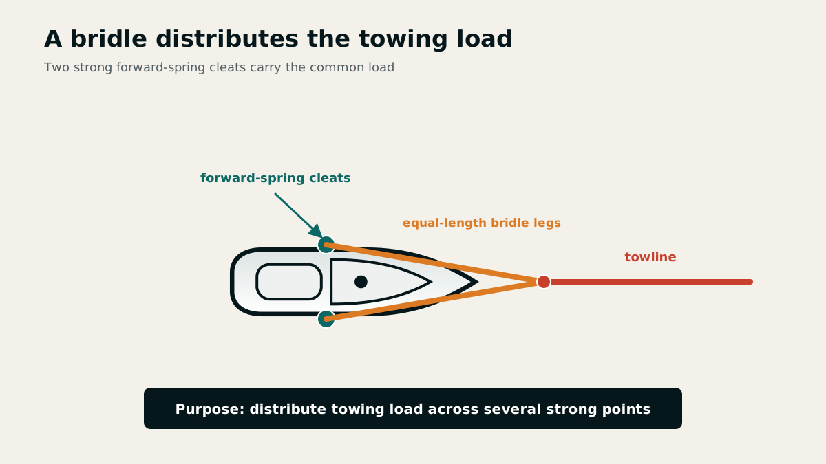
Selecting suitable ropework
Mooring lines, anchor warps and towlines must combine breaking strength with elasticity. Knots can reduce breaking load by as much as 50 per cent. Eyes, splices and correctly sized shackles are generally better for sustained loads; a sewn whipping prevents the core moving inside the cover.
At least four fenders and four mooring lines are supplemented by spare rope, a heaving line, towline and anchor warp. Protect chafe points with secured hose or cloth. Keep lines clear of the propeller, feet and snap-back zones.
Before manoeuvring, specify the length, diameter, securing point and intended purpose of every line. A line that is too short cannot absorb tidal change or vessel movement elastically.
To prevent chafing in fairleads or at pier edges, slide a plastic hose over the rubbing point and secure it against slipping; cloth strips are an alternative.
Mooring with bow line, stern line and springs
Alongside, bow and stern lines secure the ends while forward and aft springs prevent movement along the quay. Long lines led at shallow angles absorb movement better. In tidal waters, water level, draught and line length must remain safe throughout the entire stay.
In a box berth, prepare stern lines with eyes and, in a crosswind, place the windward one over its pile first. A fender board and two fenders bridge projecting piles. Commands identify the line and direction clearly.
No crew member should try to stop a multi-tonne vessel with a hand or foot. If the approach cannot be controlled, fend off, put the engine in neutral, withdraw and make a new approach.
Towing and connecting the anchor rode
A bridle distributes towing forces across several strong securing points, typically the forward-spring cleats. Lead the towline clear and provide shock absorption; keep people away from the loaded line. Agree communications, speed and the abort signal before taking the strain.
A chain leader or all-chain rode keeps the pull at the anchor shallow and protects against seabed chafe. The official guide value is three to five metres of chain leader. Secure chain to the vessel with a rope strop that can be cut in an emergency.
Deploy anchor and warp separately and under control. Throwing them together risks fouling; a knot at the anchor reduces line strength unnecessarily.
Anchor chain helps the anchor dig in, increases holding power, reduces the swinging room, cushions snatch loads and cannot chafe through on rocks like rope. The systems are often combined with 3 to 5 m of chain between anchor and warp.
Chapter 33 · 17 questions
Anchoring gear and anchoring manoeuvres
A motor yacht's engine permits precise approaches but cannot replace suitable seabed, a low pull angle and disciplined holding checks.
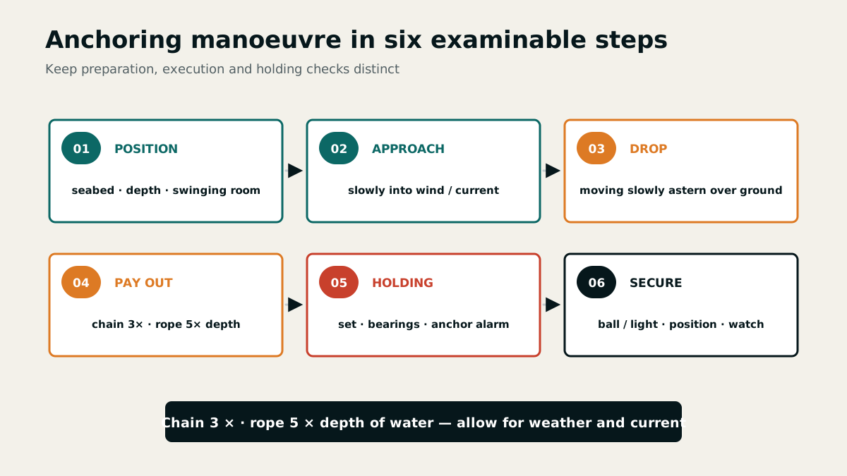
Selecting anchorage, seabed and ground tackle
The nautical chart and sailing directions describe seabed and depth. On arrival, assess shelter, swinging room, tide, wind shifts, current and neighbouring vessels. Sand, mud and soft clay suit common lightweight anchors; rock, dense weed and very soft mud are problematic.
Light-coloured water often indicates sand and dark water vegetation. A stocked anchor may penetrate weed better; patent, plough and other lightweight anchors need suitable ground. A second anchor of a different type provides both backup and tactical options.
The crew must know the release mechanism, brake, chain markings, safe hand positions and emergency release. Do not use the windlass and bow roller as the sole means of securing the rode.
Several anchors, preferably of different types, provide a replacement after loss, permit warping or tandem anchoring, suit different seabeds and allow lying to two anchors in heavy weather or tidal waters. The model answer lists Bruce, CQR, Danforth and D'Hone as high-holding-power anchors; three examples are required.
The manoeuvre in clear phases
Plan the anchoring position and approach, then prepare the ground tackle and anchor signal. Approach into wind or current at the slowest controllable speed. Lower the anchor while moving gently astern over the ground and pay out chain or warp without piling it up.
Official guide values are about three times water depth for chain and five times for rope; weather, freeboard, current and available room may require more. Set the anchor, place the engine in neutral and record the position and swinging room.
An anchor ball by day and anchor light by night are integral to the manoeuvre. An anchor buoy marks the position and its tripping line assists recovery, but it must not create a hazard for other vessels.
Pull angle and holding checks
Chain, a chain leader and an anchor sentinel pull the warp towards the seabed, keep the angle shallow and absorb snatch loads. As wind increases, pay out more rode; in confined space a sentinel may help if swinging room and neighbouring vessels permit.
Check holding by setting the anchor, feeling for absence of vibration, taking repeated bearings and distances and using a GPS anchor alarm. One observation is insufficient. A shift of wind or current may reload an anchor that previously held.
When weighing anchor, use the engine to bring the bow over the anchor and remove the strain from the chain. The windlass retrieves the unloaded ground tackle; it must not pull the vessel against wind and sea.
Chapter 34 · 14 questions
Harbour, heavy-weather and MOB manoeuvres
Engine power creates options but also considerable energy. Safe manoeuvres use the lowest effective speed, clear crew roles and an open escape route.
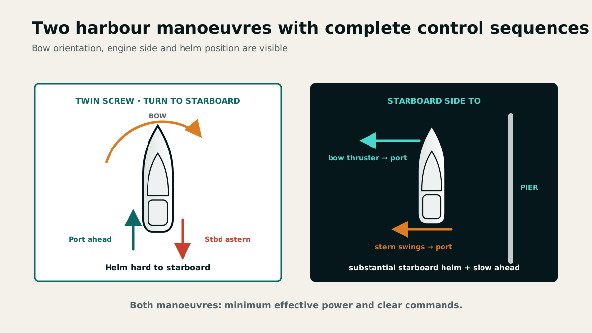
Berthing, leaving and turning
Before a harbour manoeuvre, assess wind, current, berth and abort route; prepare fenders and lines and assign crew. In a box berth, prepare stern lines and, in a crosswind, secure the windward pile first. A bow thruster assists at low speed but loses effectiveness as headway increases.
To turn a twin-screw vessel to starboard, put the rudder hard to starboard, run the starboard engine astern and the port engine ahead. When leaving starboard side to an alongside berth, the bow thruster can push the bow to port while starboard rudder and slow ahead power move the stern away from the quay.
The lowest effective speed limits energy and damage. Use short, planned bursts of power; neutral intervals reveal how wind and current are actually moving the vessel.
Alongside a pier in tidal waters, depth must suffice at low water or safe grounding must be assured. Mooring lines must accommodate the tidal rise and fall; with a larger tidal range the yacht must not be left unattended.
The bow thruster is useful when berthing, leaving a berth and turning in confined space.
Heavy sea and coastal proximity
Strong onshore wind may make a harbour entrance impassable through breaking seas over shoals, cross seas and cross-current eddies. Near the coast, seek shelter or a safe harbour early; if that is impossible, keep the yacht headed into the sea at a suitable speed and secure the crew.
An angle of about 20° to 25° to the wave direction can reduce pounding on a motor yacht. Reduce speed until the propellers and rudders remain effective without overloading hull or crew.
Wind against current produces a short, steep sea. A following current increases speed over the ground while the log reading through the water remains unchanged. Assess navigation and ETA from both quantities.
Searching for and recovering a person overboard
The alarm call, flotation aid, lookout, MOB marking, engine control and return manoeuvre form one rehearsed sequence. Approach so that wind and sea do not force the casualty beneath the vessel, and disengage the propeller in good time.
A marker buoy with flashing light and the MOB key preserve the search datum. Visual contact remains essential because the casualty drifts. Once a line is secured, use a fixed boarding ladder, foot loop, tackle or recovery strop to bring the person aboard as horizontally and gently as possible.
After recovery, prevent further heat loss, check breathing and circulation, give first aid and transmit a distress alert if required. Prevention begins with lifejackets, safety harnesses, jackstays and clear rules for night and heavy weather.
To prevent falls overboard, wear and clip in safety harnesses, rig jackstays from bow to stern and show the crew the attachment points for their tether hooks.
Chapter 35 · 22 questions
Fire protection, damage control and rescue
Emergencies are controlled by prepared systems rather than individual devices. Alerting, damage control and rescue proceed in parallel under clear command.
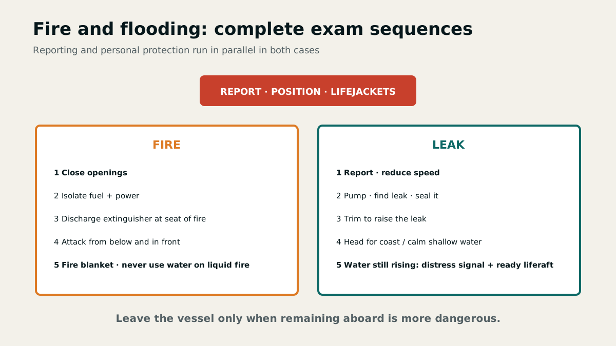
Personal and technical safety equipment
Lifejackets and safety harnesses must fit every person and are worn at night, in heavy weather and for hazardous work. Keep the liferaft, lifebuoy, jackstays, first-aid equipment, radio, signals, leak-stopping materials, pumps and radar reflector accessible.
Service labels and certificates state maintenance dates for the liferaft, automatic lifejackets and extinguishers. Distress signals include red flares and rockets, orange smoke, a signal pistol, flags N over C, a signalling lamp, dye marker and EPIRB. Use them only in a genuine emergency that cannot be overcome without outside assistance.
Mount a radar reflector as high and securely as possible; active systems further improve detectability. In emergencies, VHF may be used without the relevant certificate.
The catalogue names the BSH publication “Safety at Sea and in Coastal Waters: Rules of Care for Recreational Boaters” and “Safety on the Water: A Guide for Recreational Boaters” from the Federal Ministry of Transport, Building and Urban Development named there. Such guidance is also used when assessing recreational boating accidents.
Prevention means wearing and clipping in safety harnesses and ensuring the crew knows the attachment points. A jackstay is a taut wire, webbing strap or strong line beside the toe rail between cockpit and foredeck, used for clipping in a safety tether.
Safety equipment for a 10-metre yacht includes bilge pumps and buckets, leak-control materials, extinguishers, tools and spares, distress signals, torches, radio, anchor, first aid kit, radar reflector and lifesaving equipment. Name at least six in the examination.
Smothering fire and limiting flooding
For a fire: raise the alarm, protect people, close openings, isolate fuel and electrical supplies, and direct the correct extinguisher at the seat of the fire. ABC powder covers several fire classes and CO₂ suits enclosed engine spaces. Never fight a liquid-fuel fire with water.
Mount extinguishers ready for use and readily accessible near the engine space, galley or heater. Observe the inspection date on the label and protect against moisture and corrosion. Keep CO₂ extinguishers outside the vessel's interior because leakage may cause suffocation. A fire blanket, bucket and extinguisher port for the enclosed engine space complete the equipment.
For flooding: report, reduce speed, pump, locate and seal the leak, and use trim to reduce inflow. If the water rises, prepare a distress alert and evacuation and, where possible, head for calm shallow water for a controlled grounding.
Grounding and heavy impacts, for instance while berthing, are more than an annoyance: they can damage the hull, and that can put the boat in danger of sinking. After any hard contact, check the bilge and the forward compartment before continuing.
Sea distress, liferaft and helicopters
Remain calm, transmit a distress alert, put on lifejackets and warm clothing, prepare the liferaft and stay aboard as long as reasonably safe. The vessel is larger, more sheltered and easier to locate than the raft.
Before transferring, place water, provisions, signals, an EPIRB, a search-and-rescue radar transponder and a handheld VHF in the raft. During helicopter rescue, keep the winch wire free and never attach it to the vessel; use the strop and karabiner as instructed.
Supervise seasick people, clip them on and keep them hydrated. Exhaustion and hypothermia impair judgement and mobility, so reassign duties early.
During helicopter rescue, let the winch wire hang free and never secure it to the vessel. With an open rescue strop, clip the karabiner first, pass head and both arms through the strop, press the arms down and clasp the hands. Follow the aircrew's instructions.
Chapter 36 · 9 questions
Passage preparation, crew and onboard routine
Before every passage, motor yachts require a complete check of propulsion, reserves, navigation and crew. Standard routines prevent small omissions becoming emergencies.
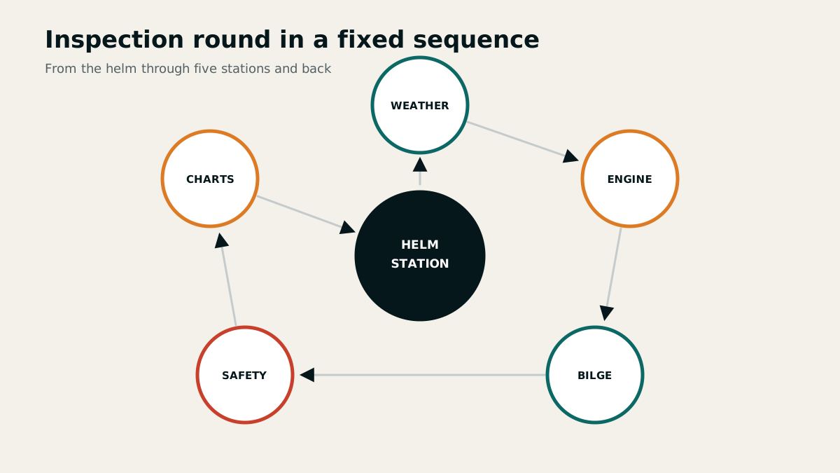
A complete check before departure
Before every departure, check weather, route, corrected charts, fuel, drinking water, bilge, engine, gearbox, cooling, navigational equipment, lights, sound-signalling appliances, pumps, extinguishers, lifesaving appliances and documents. Allow reserves for diversions, adverse current and a change of destination port.
Do not merely count safety equipment; check its maintenance, accessibility and function. Stow loose objects and set hatches and seacocks for operation. A night passage also requires additional rules for lookout, lighting and redundancy.
Wash an antifouling-coated hull only at a suitably equipped cleaning facility. Collect water and residue rather than letting them enter the drains. Oil and contaminated bilge contents also belong at an appropriate reception facility.
Briefing the crew on systems and emergencies
Everyone is shown the ground tackle, bilge pumps, extinguishers, engine, seacocks, radio, MOB button, distress signals and emergency steering. The briefing covers location, purpose, operating sequence and typical hazard. More than one person must be competent with every critical system.
The marine toilet follows a fixed sequence: open the inlet, flush, close the inlet, pump the bowl dry and close the seacocks. Incorrect operation can flood the vessel, so demonstrate the pumps and valves in practice.
Set the logbook routine, watch plan and responsibilities before departure. Fatigue, weather and experience determine helm manning; use the outside helm in restricted visibility or confined waters.
All crew members should know the location and operation of every pump and valve so that anyone can use them when needed.
Logbook and current situation picture
The logbook records crew and duties, start and end of the passage and regular entries for position, course, speed, current, weather and atmospheric pressure. Engine hours, fluid levels, faults, manoeuvres and decisions complete the picture.
Time every entry and review the log together at a watch change. A GPS track or engine display does not replace a written assessment because it records neither reasons nor observations.
On an unfamiliar yacht, test gearbox controls, transverse thrust, stopping characteristics, helm positions, bow thruster, emergency steering and anchoring system in sheltered water before attempting demanding manoeuvres.